TEMPAT - TEMPAT PEMBERHENTIAN MUSA KETIKA EXODUS
Introduction:
- The exodus Route has about 50 stops and traverses 7 wildernesses. If we used the Bible exclusively, we can know only 3 of the of the 50 exodus stops for certain: Goshen, Ezion Geber, Mt. Nebo. Of the 7 wilderness areas Israel passed through, we only know one for certain: Wilderness of Shur.
- The search for the exodus route has produced many different options: Mt. Sinai (18 different locations) The Red Sea crossing point (7 locations) and Kadesh Barnea (16 locations). Most of these options can be ruled out because they conflict with scripture.
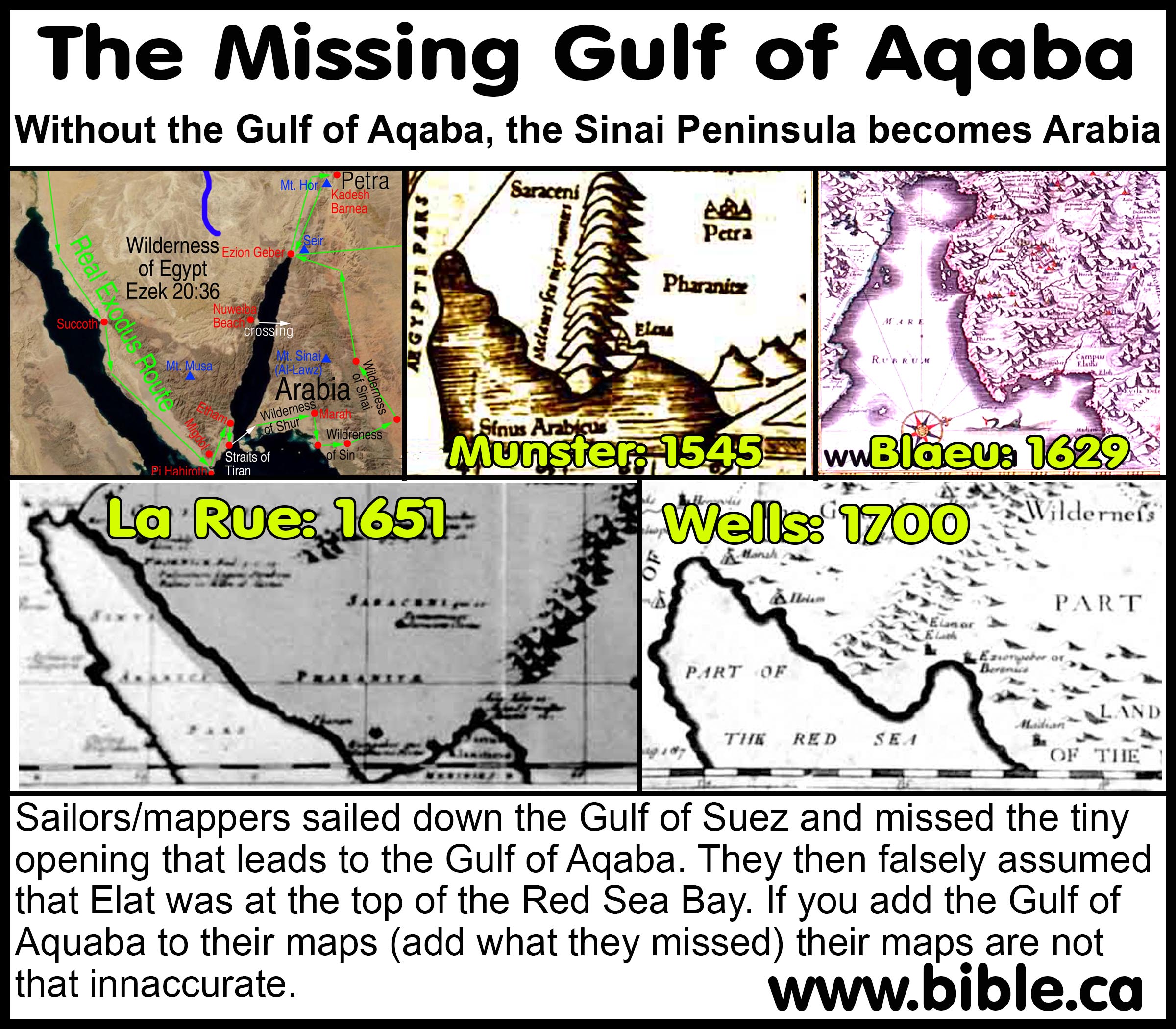
- Paul said in Gal 4:25, that Mt. Sinai is in Arabia. This is a huge problem for those who believe Mt. Sinai is located at Mt. Musa in the middle of the Sinai Peninsula. First they argue that the Sinai Peninsula is not controlled by Egypt or part of Egypt. This contradicts the Bible in Gen 15:18, that says the Wadi el Arish is the border between Egypt and Israel. When this fails, they appeal to ancient geographers and maps to show that the Sinai Peninsula was called Arabia. Although this sounds convincing, the fact remains this contradicts history because when Paul wrote Gal 4:25, it was at least 50 years before the Sinai was first called Arabia in 106 AD, when the Romans annexed this land. Totally stumped, they finally they pull out an ancient map and say, "See! The land east of Goshen in Egypt was called Arabia." The problem is that they failed to look at the map themselves and notice that the Gulf of Aqaba is missing and the Sinai Peninsula does not exist. This is because the Gulf of Aqaba is missing and the Sinai Peninsula were not understood until about 1800 AD.
- Today we can prove from scripture that the Red sea crossing is somewhere on the Gulf of Aqaba into Arabia which forces Mt. Sinai to be located in modern Saudi Arabia. The Straits of Tiran are a perfect fit and the best possible choice.
- The scriptures also prove that Kadesh Barnea is located Transjordan somewhere south of the Dead Sea. This is achieved by studying what the Bible says about the southern border of Judah in relation to Kadesh. More.
- Taking into account everything that the Bible says, the best educated guess for the crossing of the Red Sea is at the Straits of Tiran, Mt. Sinai at Mt. Lawz and Kadesh Barnea at Petra or just north of Petra.
A. What historic exodus route maps teach us
- Foremost, it is a bit of a shock, that from the time of 700 BC down to 1750 AD, Geographers simply had no firm concept of the Gulf of Aqaba or the Sinai Peninsula. The Red sea is a single finger of water that becomes the Gulf of Suez at the top. It is like they just chopped off the Gulf of Aqaba from the Red sea and ignored it.
- This sheds some important light on why certain choices were made, historically, for the exodus route. It also explains why some mistakenly thought that Arabia came right next to Egypt.
- Since these geographers did not know about the Gulf of Aqaba, they were forced to have a crossing point of the Red Sea on the north tip of the Gulf of Suez and a Mt. Sinai in the Sinai Peninsula. Had they known about the Gulf of Aqaba, perhaps they would have considered a crossing point on the Gulf of Aqaba. It is likely this confusion, that led Constantine's mother to chose Mt. Sinai where she did at Mt. Musa, in the middle of the Sinai Peninsula.
- The Egyptians must have known about the Sinai and Gulf of Aqaba, since they had a sea port at the north end of the Gulf of Suez and another at the island of Jezirat Faraun. This was to facilitate their mining operations from about 1600 to 1250 BC at Timna. The Egyptians must have had a working knowledge of the Sinai and the two gulfs. But this should not surprise us, since the Sinai Peninsula has always been part of Egyptian territory up to the Wadi el-Arish.
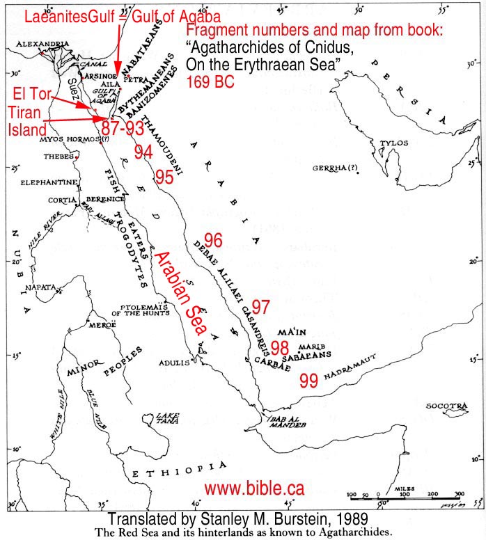
- There are a few notable exceptions to this ignorance of the Sinai and Gulf of Aqaba. Agatharchides: 169 BC understood the Gulf calling it the "Laeanites Gulf".
- The description of the Red Sea crossing by Philo of Alexandria: 50 AD clearly rules out any crossing point at the Bitter Lakes or the North tip of the Gulf of Suez. This forces a crossing point somewhere on the Gulf of Aqaba and places Mt. Sinai in modern Saudi Arabia.
- Josephus: 110 AD believed that Aaron died on Mt. Hor at Petra, which is one stop from Kadesh Barnea.
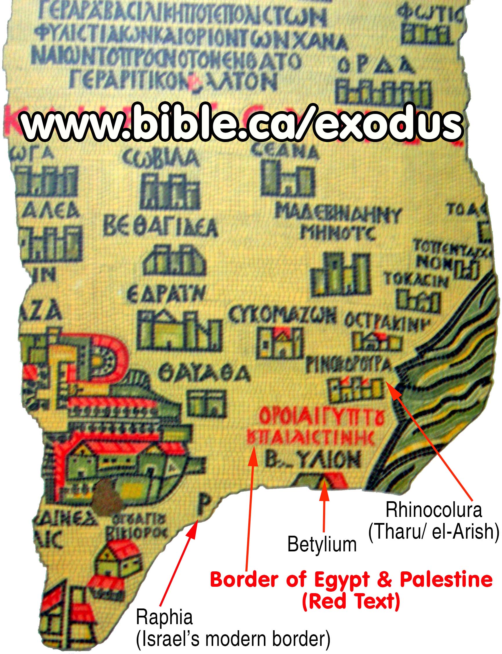
- Eusebius, Onomasticon, 325 AD is the first in a long line of historians and mappers who located Kadesh Barnea, transjordan at or near Petra. Like Josephus, he also viewed Mt. Hor at Petra to be the burial mountain of Aaron. Eusebius also correctly understood that the Wadi el-Arish is the formal boundary between Egypt and Israel. He also viewed the wilderness of Paran and the wilderness of Shur to be Transjordan.
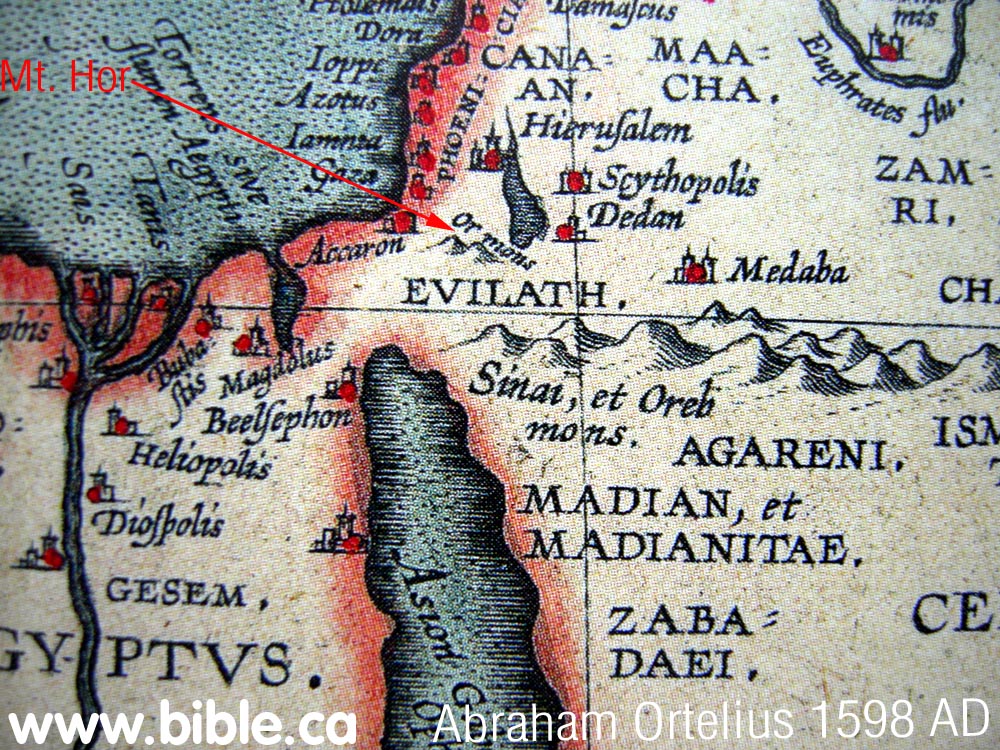
- It is not what the The Madaba map, 542 AD, actually has, but what is missing that is all important. Parts of the Madaba map were vandalized by the Muslims in 700 BC. The location of Kadesh Barnea has been located at Ein el-Qudeirat on all Bible maps only since 1916 AD. The large area of the map that was not damaged, is Qudeirat is located, yet Kadesh is NOT located there on the Madaba map. It is clear, that those who created the mosaic map did not believe Kadesh was located at Qudeirat. Since they used Eusebius, who believed Kadesh was at Petra, as a resource, and since the place where Petra should be located was destroyed by the Muslims, it seems a rather simple educated guess that they located Kadesh at Petra.
- Starting in 1500 AD down to the about 1750 AD, we have many antique, historic maps from that era. All these maps had no concept of the Gulf of Aqaba or the Sinai Peninsula.
- Mystery solved!
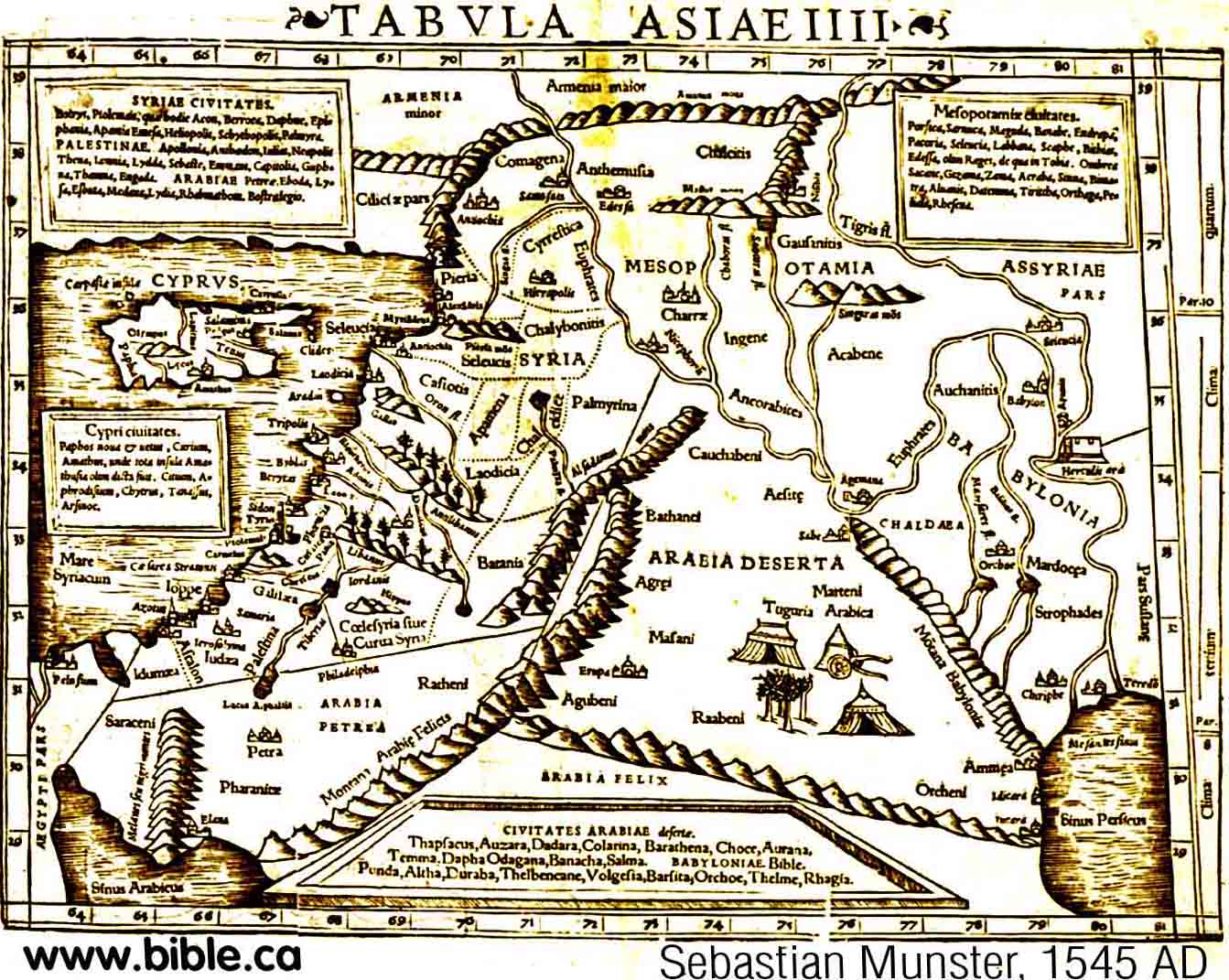
There is a unique shape of the Red Sea that was mapped by Sebastian
Munster's map in 1545 AD and others like Mercator (1584), Blaeu (1629), La
Rue (1651), Visscher (1660), Moxon (1671), Wells (1700), Vaugondy (1743).
When you compare this shape to a satellite map, you will notice they
sailed right by the two narrow openings that led up the Gulf of Aqaba and
missed it! They wrongly assumed that Ezion Geber/Elat were located at the
bay to the east of where the Gulf of Aqaba opens onto the Red Sea. This
explains the mystery of how they missed the long finger of water we know
as the Gulf of Aqaba. It is not so much that the sailors who mapped these
waters were careless or incompetent. Rather they mapped exactly what they
saw. But they sailed right past the tiny Straits of Tiran, likely 5 or ten
miles to the west simply missed the Gulf of Aqaba. If you take Munster's
map and simply add the Gulf of Aqaba, it becomes quite accurate in shape!
Remember, the sailors were not familiar with the local geography but were
from Europe, France, Italy, England, Spain, Netherlands. I have spend many
weeks sailing and navigating on a ship and can attest first hand, to how difficult
it is to map a shoreline from a boat.
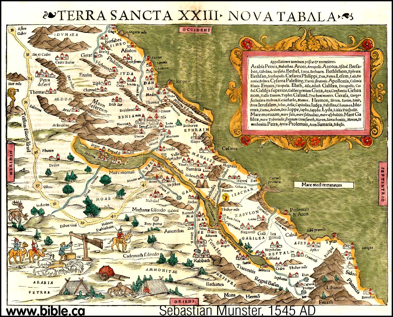
- Sebastian Munster's map in 1545 AD showed Kadesh Transjordan and Mt. Hor near Petra.
- In 1587 AD, Abraham Ortelius had a crossing point for the Red Sea at the North end of the Gulf of Suez. Since he had no understanding of the Sinai Peninsula or the Gulf of Aqaba, he really had no other choice. Had he known about the existence of the Gulf of Aqaba, perhaps he would have chosen a different crossing point. But he also clearly shows Kadesh and Mt. Hor
- What is very interesting is that the location of Petra was unknown in 1600 AD. It was rediscovered in 1812, by John Lewis Burckhardt. Yet maps before 1812 AD knew of its existence but they were not sure where to locate it. For example, in 1587 AD, Abraham Ortelius had two locations for Petra and Kadesh Barnea. A precedent for mapping uncertain locations in two places is also found in the Madaba map regarding the location of Mt. Gerizim and Mt. Ebal. Just as the Madaba Map has two locations for Gerizim and Ebal, so too does Abraham Ortelius's map have two locations for Petra and Kadesh Barnea. What is clear, however, is that Abraham Ortelius located Kadesh Barnea beside Petra. He just didn't know where Petra was!
- The maps of Sebastian Munster (1545 AD) and Abraham Ortelius (1587 AD) and Jan Jansson (1630 AD), used a numbering system for the exodus route stops. Kadesh Barnea was at "stop 33", which is one after Ezion Geber (stop 32) and one before Mt. Hor (stop 34). It is clear that this is a Transjordan location for Kadesh Barnea. What is important, is that the placed Kadesh Transjordan before they know the location of Petra which was rediscovered I 1812 AD by Burckhardt.
- In 1650 AD, Thomas Fuller placed Mt. Seir is Transjordan, due east of the Dead sea.
- In 1670 AD, Frederick De Wit clearly mapped Mt. Sinai, Kadesh and Petra to be Transjordan.
- In 1762 AD, Carsten Niebuhr is one of the first to actually draw the Gulf of Aqaba, although his understanding was limited. He also placed the "Straights of Tiran" on the map! This is the crossing point of the Red Sea, although he probably didn't know it at the time. However he incorrectly mapped the north end of the Gulf of Aqaba as a "forked tongue".
- In 1794 AD, Thomas Kitchin gives the first detailed view of the Sinai Peninula and the Gulf of Aqaba. Of course he locates Mt. Sinai at Mt. Musa following Catholic tradition.
- In 1822 AD, Johann Burckhardt discovers Petra and is the first man in history to correctly draw the Arabah Valley.
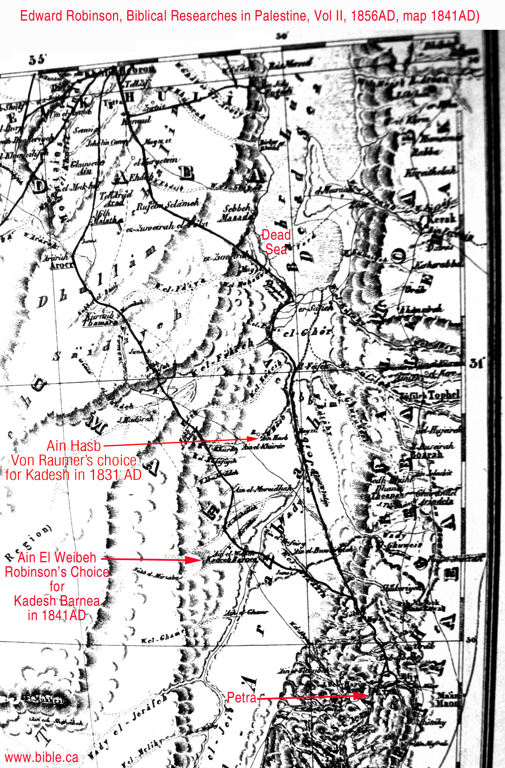
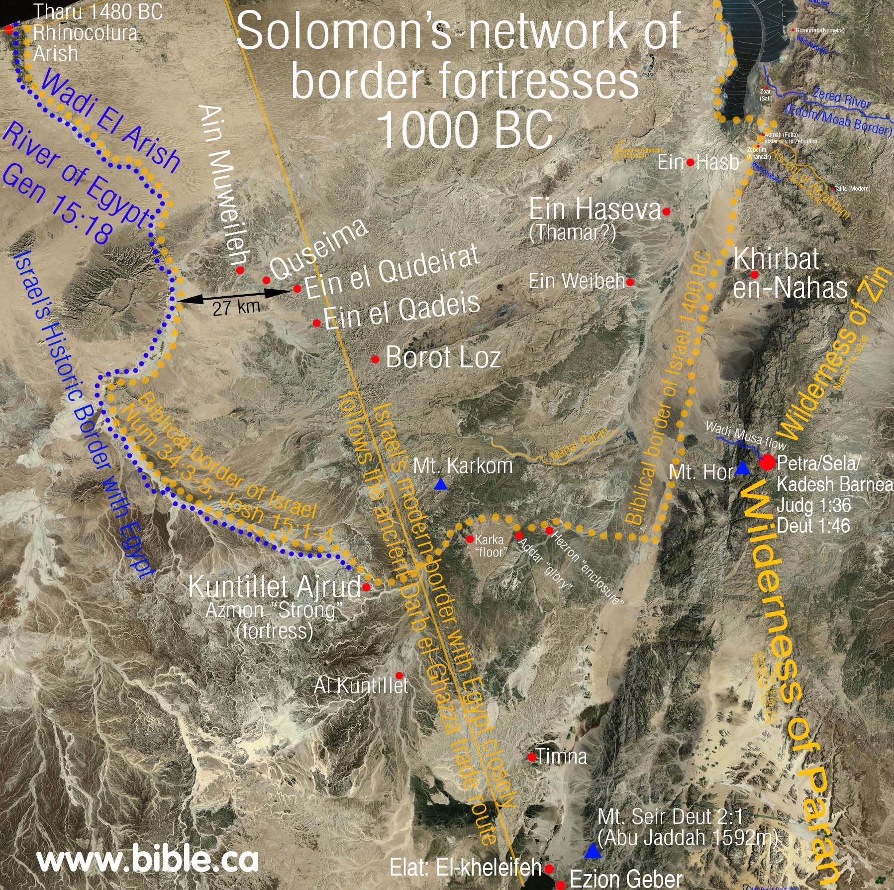
- Historically up to 1831 AD, Kadesh was located transjordan either at or near Petra. In 1831, Karl Von Raumer's chose Ein Hasb for Kadesh Barnea, but this was rejected by Robinson in 1841 AD who placed Kadesh at Ain Weibeh just a few km south of Hasb. News of Petra's discovery opened up a new world of exploration in this area. Click here for more discussion and maps of Ein Hasb and Ain Weibeh. Both Hasb and Weibeh were located near Petra, but should have been rejected since they are both in side the promised land of Judah.
- In 1849 AD, Carl Radefeld reflected the thinking of his time by locating Kadesh at Ein el-Weibeh, where Edward Robinson had chosen in 1841 AD. This map is like a little time capsule of history showing Kadesh located at Weibeh.
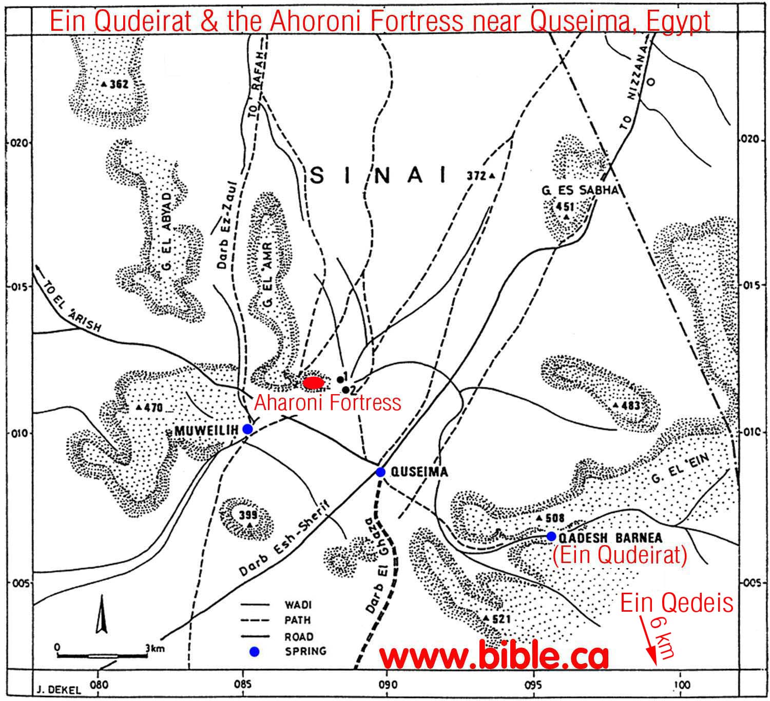
- In 1881 AD, Weibeh was dethroned as the location for Kadesh in favor of Ein Kades (Ein-Qedeis). This was the beginning of the "dark ages" in the search for Kadesh. Kades should have been automatically rejected since it is 27 Km inside the promised land of Judah.
- From 1881 -1916 AD Ein-Qedeis was the location of Kadesh Barnea in the eyes of the world, although there were some who rejected this in favor of Petra. But in 1916 AD, Kadesh was moved about 6 km north of Kades to Ein el-Qudeirat.
- In 1914, Woolley and Lawrence excavated Qudeirat and declared it to be Kadesh Barnea. Since they published their work in 1916 AD down to the present time, almost every map in the back of every Bible places Kadesh Barnea at Ein el-Qudeirat. This is most unfortunate for a number of reasons, mainly because it is inside the promised land.
- See also: The Chronological History of "The search for Kadesh"
- We invite you to consider the crossing of the Red Sea at the Straits of Tiran, Mt. Sinai at Mt. Lawz and Kadesh Barnea at or just north of Petra.
B. Gallery: Historic Exodus Route maps
|
|
|
|
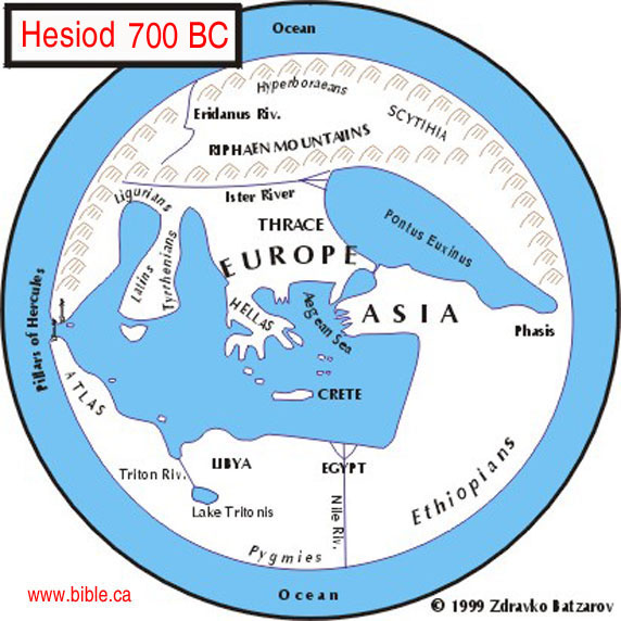
700 BC: Hesiod (Greek Poet)
This is a modern interpretation map
based directly upon the geographic understanding of the middle east by a
Greek Poet named Hesiod who lived in 700 BC. Notice he has no understanding
of the Red sea, Persian Gulf or Israel for that matter.
More: Hesiod:
700 BC
|
 |
|
|
|
|
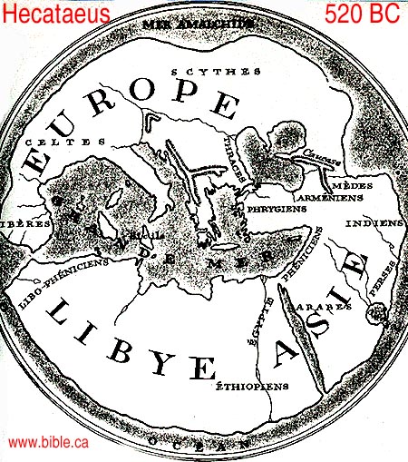
520 BC: Hecataeus (Greek Philosopher)
This is a modern interpretation
map based directly upon the writings of a Greek Philosopher named Hecataeus who
lived in 520 BC. Notice, like Hesiod his predecessor, he no concept of Israel
and has a vague understanding of the Red sea as a single finger of water.
More: Hecataeus:
520 BC
|
 |
|
|
|
|
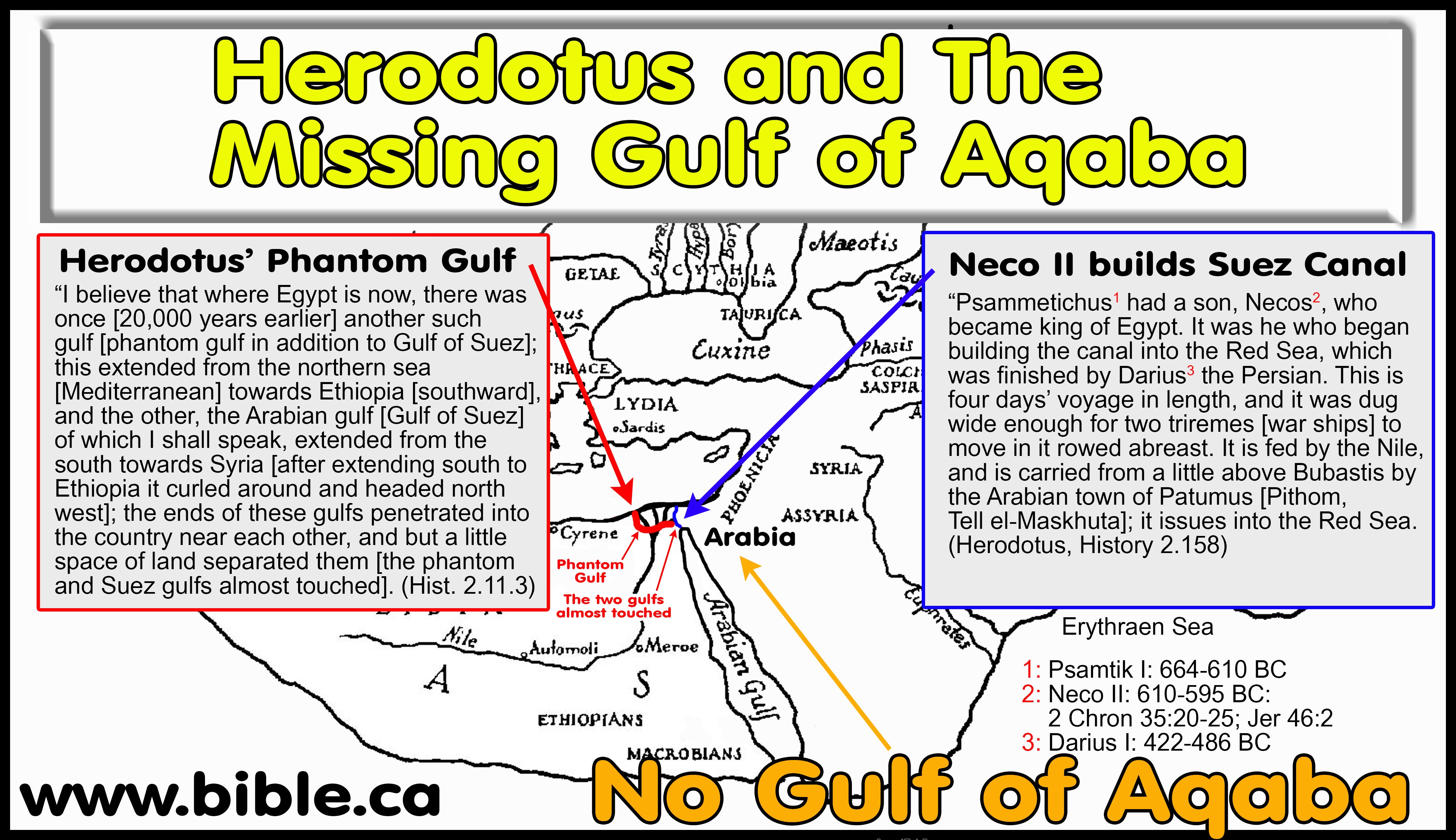
484 BC: Herodotus
This is a modern interpretation map
based directly upon the writings of Herodotus.
The Suez
Canal was first completed in 500 BC: "This prince [Necos] was the
first to attempt the construction of the canal to the Red Sea - a work
completed afterwards by Darius the Persian - the length of which is four
days' journey, and the width such as to admit of two triremes being rowed
along it abreast. The water is derived from the Nile, which the canal leaves
a little above the city of Bubastis, near Patumus, the Arabian town, being
continued thence until it joins the Red Sea. (Herodotus 2.158-159, 484 BC)
No
concept of the Gulf of Aqaba, but a strange forked tongue at the top
of the Gulf of Suez: "the two gulfs ran into the land so as almost to
meet each other, and left between them only a very narrow tract of country.
(Herodotus 2.11, 450 BC)
More: Herodotus:
484 BC
|
More:
Herodotus:
484 BC
|
|
|
|
|
250 BC: Septuagint
The Septuagint LXX, translates
Gen 45:10; 46:34 as, "Goshen of Arabia".
More: Septuagint:
250 BC
|
Septuagint LXX
This is used as proof that in 250 BC, well before Paul's time of writing Gal 4:25, that everything east of the Nile was considered Arabia. It is suggested that the Septuagint merely reflected the geographical understanding of the time. Considering they had no concept of the Sinai Peninsula or the Gulf of Aqaba, the translators copied this error from their contemporary geographers. The Holy Spirit did not make this mistake, and the works, "of Arabia" are not in the original Hebrew text. |
|
|
|
|
225 BC Demetrius the Chronographer
|
Demetrius believed that Mt. Sinai
was in Arabia. He lived and worked in Alexandria, which meant he had access
to the largest library in the world. Demetrius located Mt. Sinai in the city
of Madyan (al Bad) in northwestern Arabia. This information comes from
Eusebius in his work: Preaparatio Evangelica 9:29.1-3
|
|
|
|
|
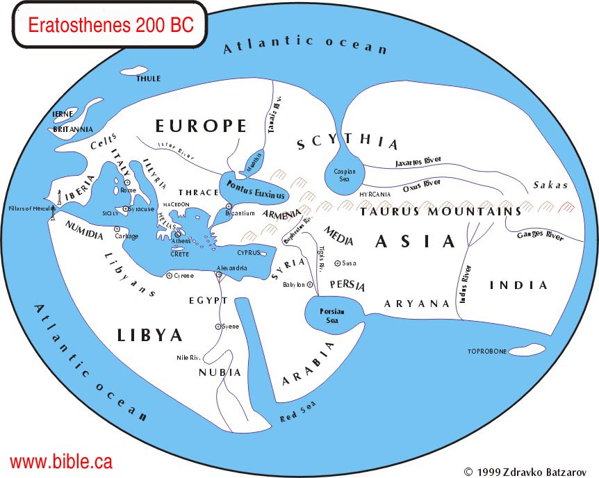
200 BC: Eratosthenes
More: Eratosthenes:
200 BC
Eratosthenes makes the same
geographical errors of his predecessors Herodotus, Hecataeus, Hesiod and Hecataeus
by ignoring Israel and having no working knowledge of the Gulf of Suez and
Aqaba. 1. In spite of this, Eratosthenes described "Arabia" in such
a way so as be equivalent to the Arabian Peninsula, which is modern Saudi
Arabia, to the exclusion of the Sinai Peninsula.
|
 |
|
|
|
|
169 BC: Agatharchides
Agatharchides is unique in that
he is the only geographer before the 1800's AD, that understood the Gulf of
Aqaba, which he calls "Laeanites Gulf". He restricts
"Arabia" to south and east of the Gulf of Aqaba. Agatharchides did
not sail down the Laeanites Gulf, but says the Arabs live on the east shore,
not the left and that at the end of the Gulf, is Petra!
More: Agatharchides:
169 BC
|
 |
|
|
|
|
150 BC: Book of Jubilees
More: Book
of Jubilees: 150 BC
|
The book of Jubilees clearly
places Mt. Sinai in modern Saudi Arabia. The book of Jubilees says that
"Mount Sinai the centre of the desert" in the land of Shem, not
Ham. Since Ham settled in Egypt and the Sinai Peninsula and Canaan (the
promised land) and Shem settled in Saudi Arabia, but not the Sinai Peninsula
or Egypt, it is clear that the book of Jubilees did not view Mt. Sinai to be
in the Sinai Peninsula, but in Saudi Arabia. The best choice for the location
of Mt. Sinai it Mt Lawz, in north Saudi Arabia.
|
|
|
|
|
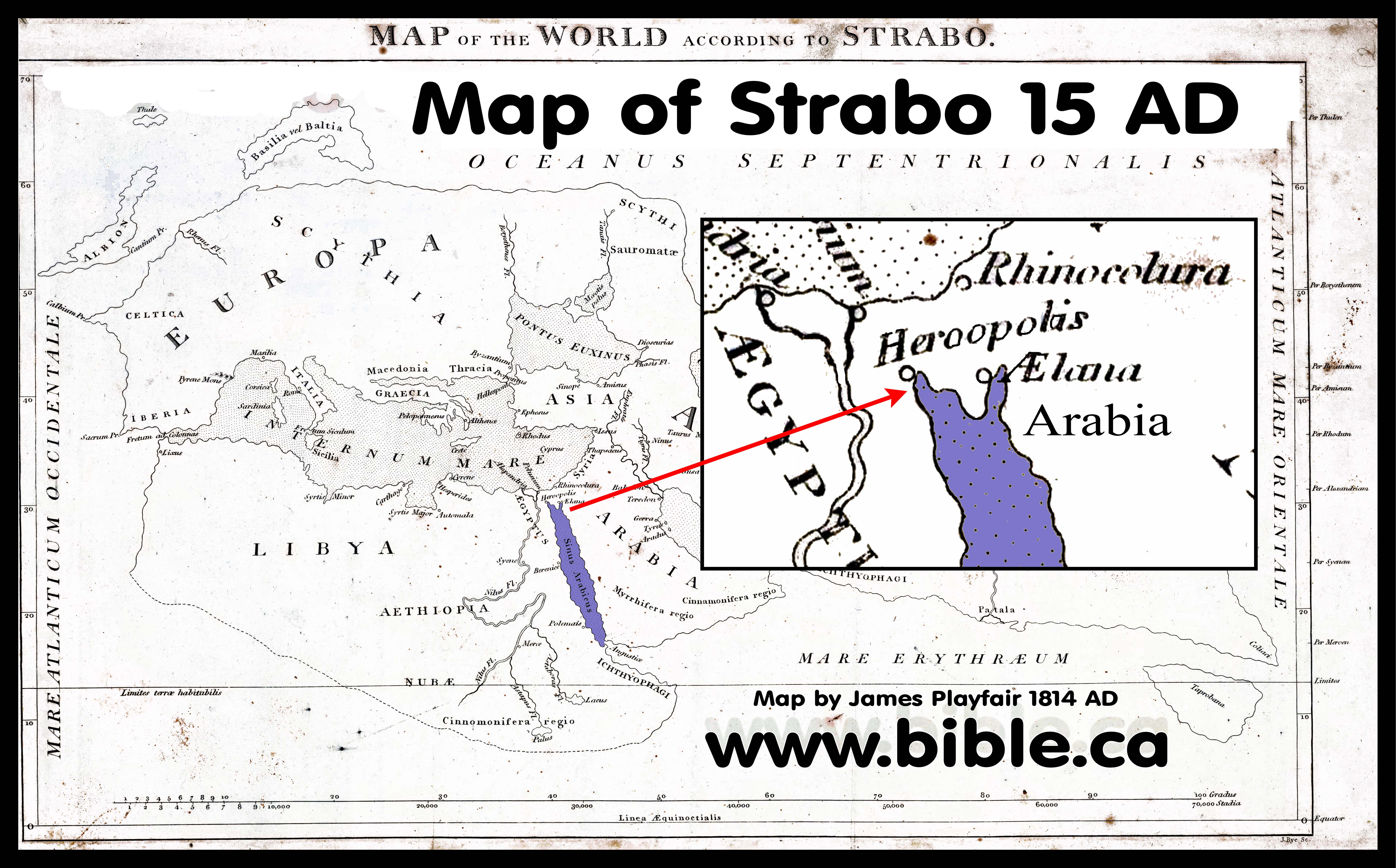
15 AD: Strabo
More: Strabo:
15 AD
Strabo viewed the Red sea as a single
finger of water and had no concept of the Gulf of Aqaba or the Sinai
peninsula.
|
 |
|
|
|
|
45 AD: Apion
More: Apion:
45 AD
|
Apion fabricated his own version
of the exodus and specifically says that Mt. Sinai was located in the Sinai
Peninsula, but that this was not in Arabia. Apion rules out Mt. Sinai located
at Mt. Musa.
|
|
|
|
|
50 AD: Philo of Alexandria
|
Philo refutes a Red Sea crossing
at both the Bitter Lakes and the North tip of the Gulf of Suez. This in turn
refutes the traditional location of Mt. Sinai chosen in a dream by
Constantine's mother in the middle of the Sinai Peninsula. Philo's use of the
terms Arab and Arabia, were restricted to the land east of the Gulf of Aqaba
where Jethro and the Ishmaelite lived, and he never says the Sinai Peninsula
is Arabia.
|
|
|
|
|
110 AD: Josephus
More: Josephus:
110 AD
|
Josephus believed that Mt. Hor
was at Petra. Josephus echoed Philo's belief that Mt. Sinai was "the
highest of the mountains" in the region. Josephus refers to Petra as the
capital of Arabia, proving he wrote after 106 AD when Petra was annexed by
the Romans and named this. Josephus' account of the exodus has been stripped
of all geographic markers.
|
|
|
|
|
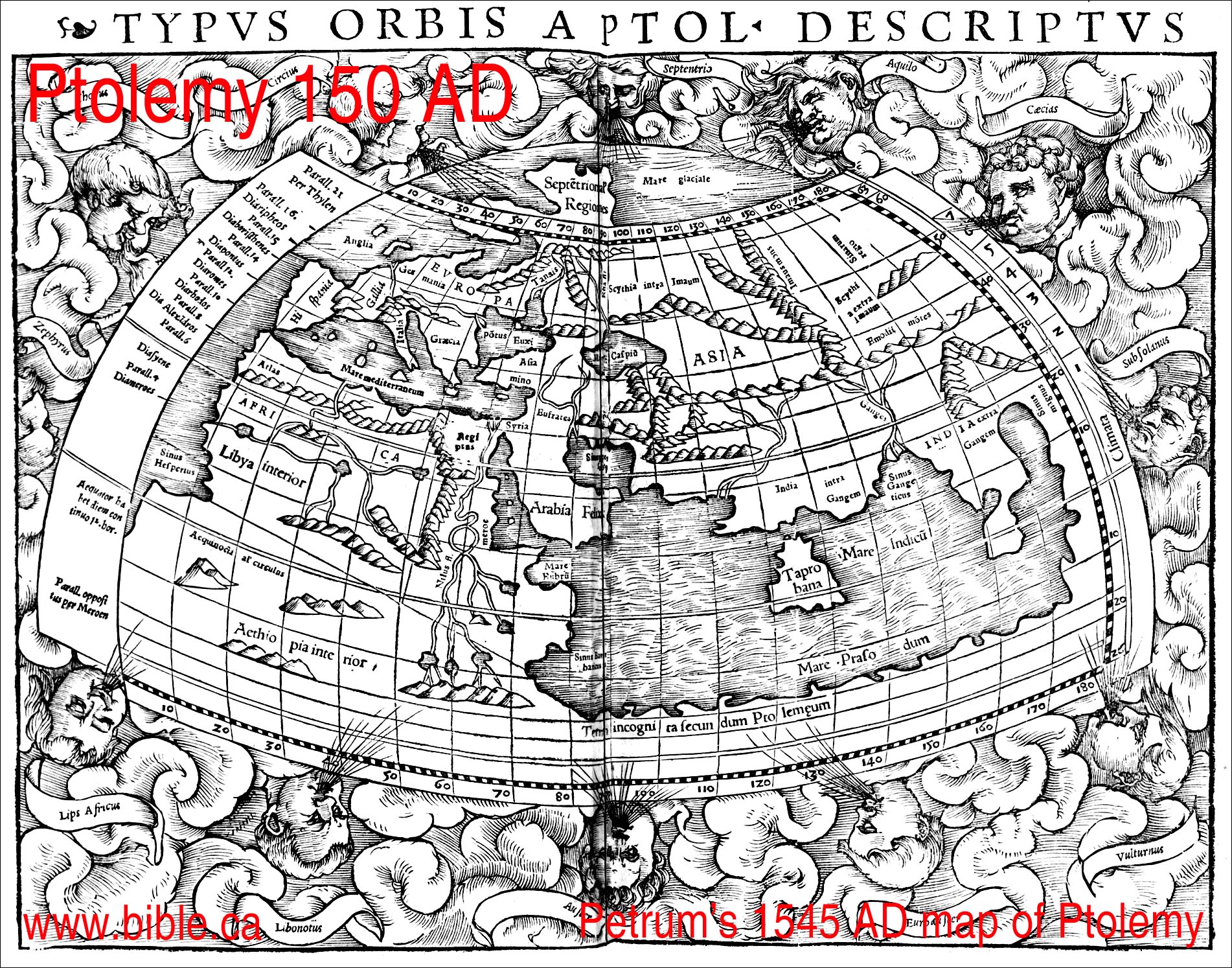
150 AD: Ptolemy
Ptolemy had no concept of the
Sinai Peninsula or the Gulf of Suez.
More: Ptolemy:
150 AD
|
 |
|
|
|
|
165 AD: Justin Martyr
More: Justin
Martyr: 165 AD
|
Justin said, "while he was
tending the flocks of his maternal uncle in the land of Arabia, our Christ
conversed with him under the appearance of fire from a bush"
|
|
|
|
|
180 AD: Clement
More: Clement:
180 AD
|
Clement said the Phoenix had its
origin in "Eastern lands, that is, in Arabia", far away from Egypt.
This indicates that the Sinai Peninsula was not viewed by Clement as Arabia.
|
|
|
|
|
325 AD: Eusebius, The Onomasticon
|
Eusebius said that Kadesh Barnea
& Mt Hor were at Petra. He also said that the Mt. Sinai, the wilderness
of Paran and Wilderness of Shur were all Transjordan. Eusebius echoes Gen
15:18, that the Wadi el-Arish is the border between Egypt and Israel. This
means that the Sinai peninsula was part of Egypt, according to Eusebius.
|
|
|
|
|
381 AD: Egeria
More: Egeria:
381 AD
|
The Diary of Egeria is not
helpful in locating Mt. Sinai, since she was merely going to the place Helena
chose in a vision a few years before.
|
|
|
|
|
400 AD: Jerome
|
Jerome held the same views of
geography that Eusebius did. Jerome was used as a resource in making the
Madaba Map.
|
|
|
|
|
550 AD: The Madaba map
Missing entirely from the Madaba Map
is the Red Sea, Mt. Sinai and Petra/Kadesh Barnea. It would certainly be on
the map, but was vandalized by the Muslims in 700 AD. Most notably, however,
is that the modern choice for the location of Kadesh Barnea at Ein
el-Qudeirat, should be in a section of the map that is fully intact.
Qudeirat should be located close to the large red text, "lot of
Simeon". This means that Kadesh is located in one of the damaged areas
and proves Kadesh is not at Qudeirat. The Madaba map was based upon the
Onomasticon by Eusebius, and Jerome.
More: The Madaba map, 542 AD
|
 |
|
|
|
|
1545 AD: Sebastian Munster
This is the first modern map we
have found. It is obvious that this basic map had been in existence for a long
time before. With the advent of the printing press, it suddenly appears all
over the world in different countries. You will notice that the practice was
to have a standard numbering system for each of the 40+ stops of the exodus.
Stop 33 is Kadesh, stop 34 is Mt. Hor. Both Kadesh and Hor are Transjordan
and east of Petra.
|
 |
|
|
|
|
1545 AD: Sebastian Munster
Notice that there is a crude
representation of the Gulf of Aqaba. However, in a later map Munster does not
show the Gulf of Aqaba at all. Kadesh would be considered transjordan. See
his detailed map above.
maps-bible-archeology-exodus-route-kadesh-barnea-gulf-of-aqaba-sinai-peninsula
|
 |
|
|
|
|
1579 AD: Cornelis De Jode
Sinai peninsula and Gulf of Aqaba
missing and viewed as a single finger of water.
Mt. Sinai and Kadesh are
transjordan.
|
 |
|
|
|
|
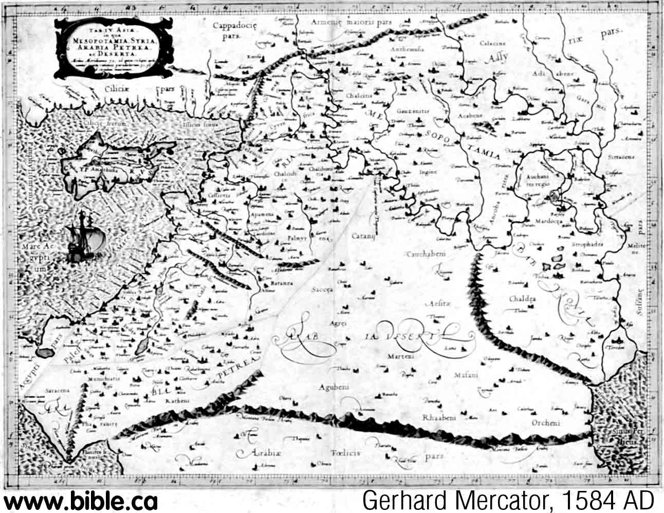
1584 AD: Gerhard Mercator
This map was copied from
Sebastian Munster's 1545 AD map. Interesting that at the time Mercator drew
this map, Munster four years later, drew a map that had no concept of the
Gulf of Aqaba in 1588 AD. (see below)
|
 |
|
|
|
|
1587 AD: Abraham Ortelius
Sinai peninsula and Gulf of Aqaba
missing. This is a typical exodus route map with standardized numbering
system. Crossed the Red Sea at the gulf of Suez. Stop 33 is Kadesh, stop 34
is Mt. Hor. Both Kadesh (Cades) and Hor are Transjordan and east of Petra.
But the map is a mess. There are two Petra's and two Kadesh's. Eusebius
speaks of two Kadeshes (Cades). The second Petra is left of stop 25. The
second Kadesh is right of stop 26. In Hebrew Questions on Gen 14:7, Jerome
says "Cades is a place near Petra called the spring of judgment where
God judged the people"
|
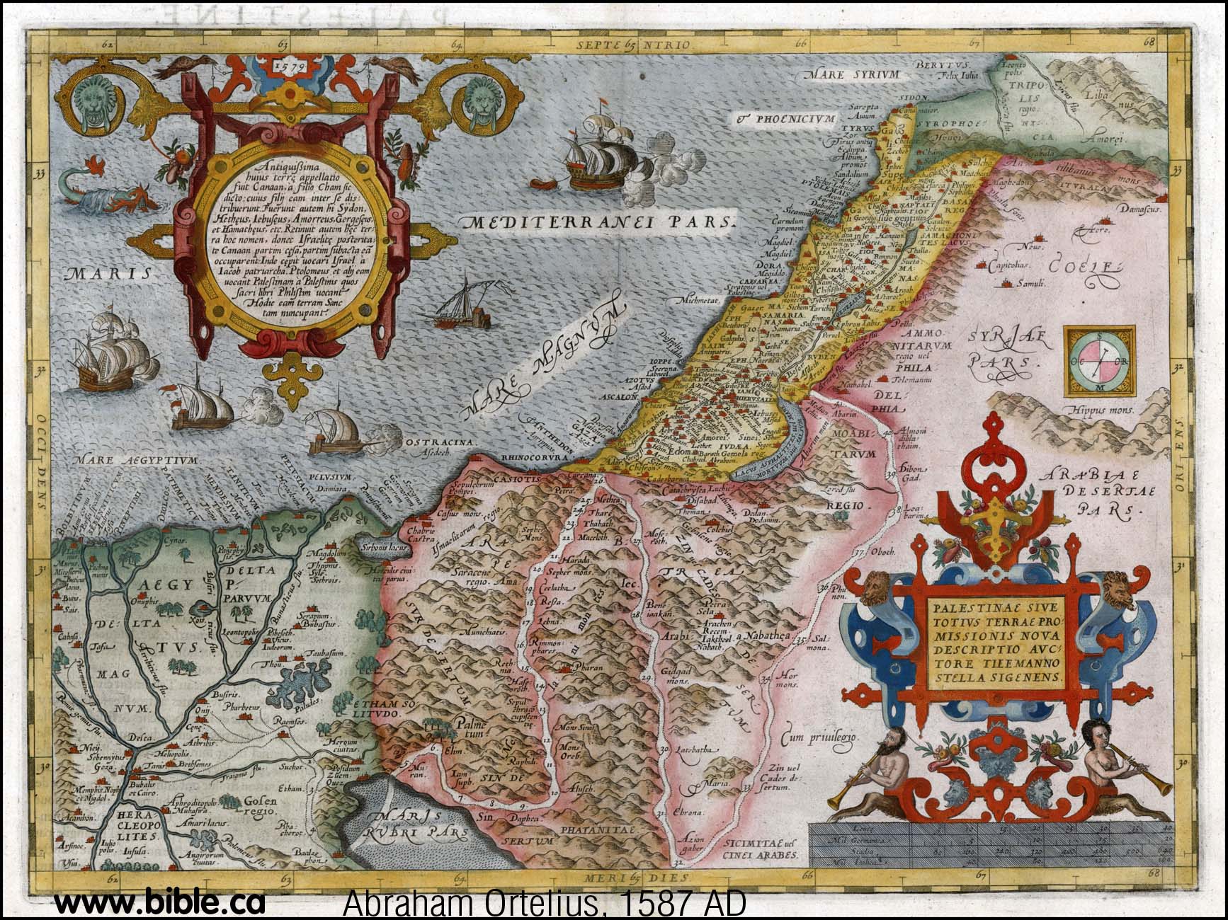
What is
important, is that Ortelius placed Kadesh Transjordan before he knew the
location of Petra which was rediscovered in 1812 AD by Burckhardt.
|
|
|
|
|
1588 AD: Sebastian Munster
Although Munster showed a crude
representation of the Gulf of Aqaba on an earlier map, here he has no concept
of the Gulf of Aqaba. It is most likely that Munster was influenced by Abraham
Ortelius who always drew the Red Sea as a single finger of water.
|
 |
|
|
|
|
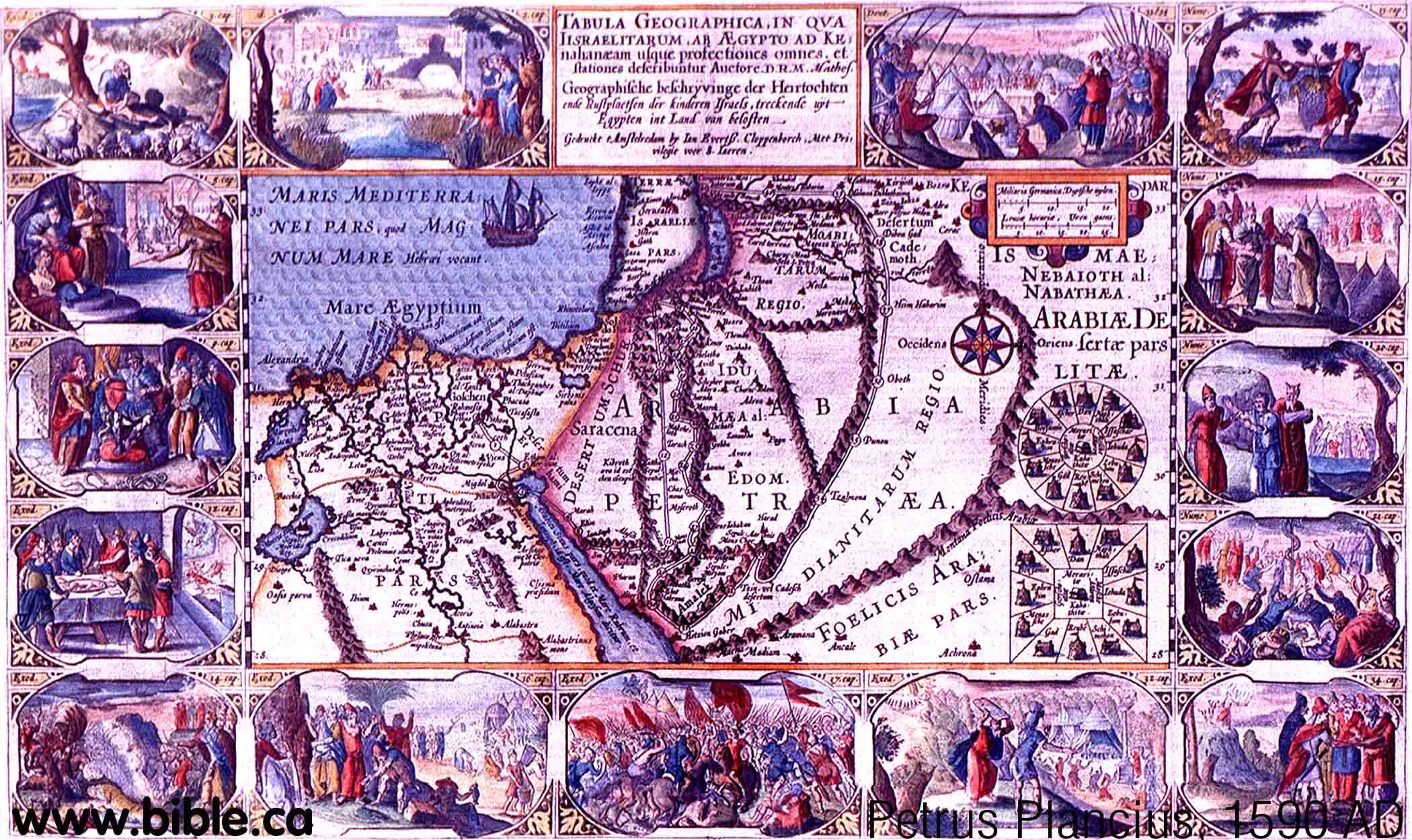
1590 AD: Petrus Plancius
This is one of the few maps that places
Ezion Geber on the Red Sea when the Gulf of Aqaba is missing. Kadesh is stop
33 of the exodus route and is transjordan. The section between Sinai and
Ezion Geber is very wrong, but this is typical of all exodus route maps when
their basic geography was so wrong.
|
 |
|
|
|
|
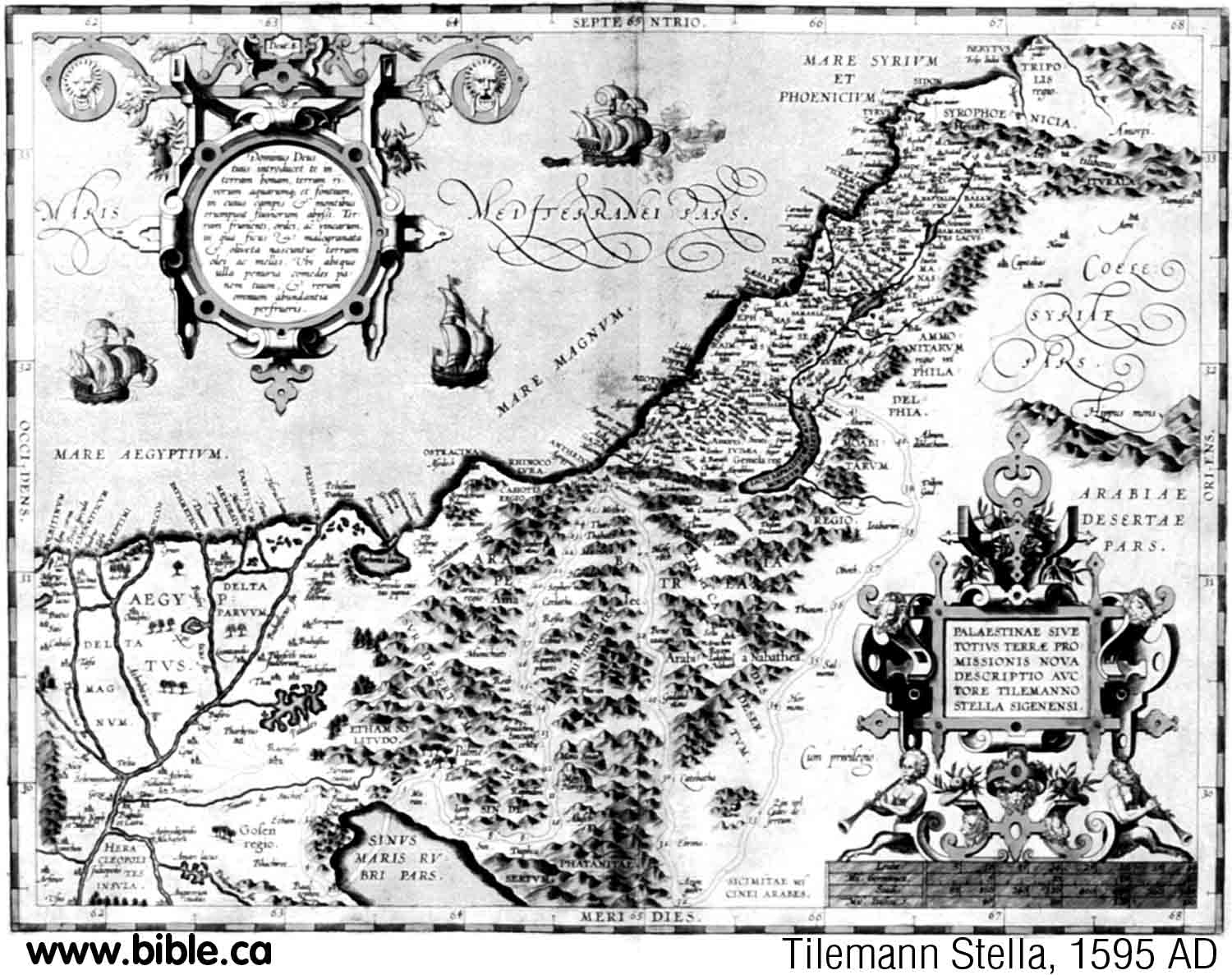
1595 AD: Tilemann Stella
This is almost an exact copy of
an earlier map done by Abraham Ortelius in 1587 AD. No concept of the Gulf of
Aqaba and Kadesh is transjordan.
|
 |
|
|
|
|
1598 AD: Abraham Ortelius
Sinai peninsula and Gulf of Aqaba
missing
Whole map and close up Israel below.
Ortelius seems to have dominated
the geography of the day. Although Sebastian Munster has shown a crude Gulf
of Aqaba in 1545 AD, he removed any trace of the Gulf of Aqaba in later maps
in 1588 AD. It is clear that Sebastian Munster was influenced by Abraham
Ortelius to wrongly draw the Red Sea as a single finger of water, completely
ignoring the Gulf of Aqaba. However, about 30 years later, (1629 AD) Willem
Blaeu must have picked up some of Sebastian Munster's earlier maps and
included the crude representation of the Gulf of Aqaba.
|
  |
|
|
|
|
1626 AD: John Speed
Sinai peninsula and Gulf of Aqaba missing. Whole map and close up Israel below. 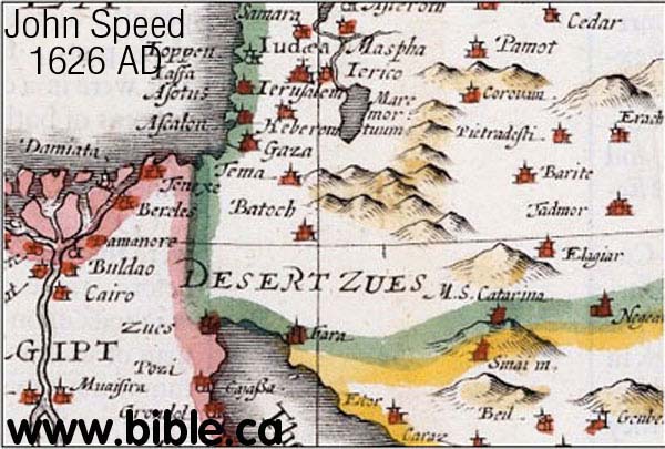 |
 |
|
|
|
|
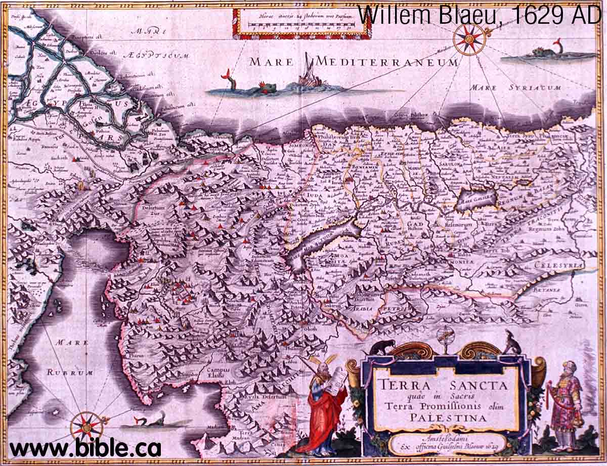
1629 AD: Willem Blaeu
Blaeu is copying from Sebastian
Munster's 1545 AD map. Different parts of the world used different maps. The
Gulf of Aqaba is not understood well, but at least it has "sprouted on
the tree"! Ezion Geber is not on the map. Notice the natural land bridge
represented at the top of the Gulf of Suez. There is a natural land bridge
here, but not as shown here.
|
 |
|
|
|
|
1630 AD: Jacobus Tirinus
The Sinai Peninsula and the Gulf of
Aqaba are non-existent. Ezion Geber is on the Red Sea and one stop before
Kadesh which is transjordan.
|
 |
|
|
|
|
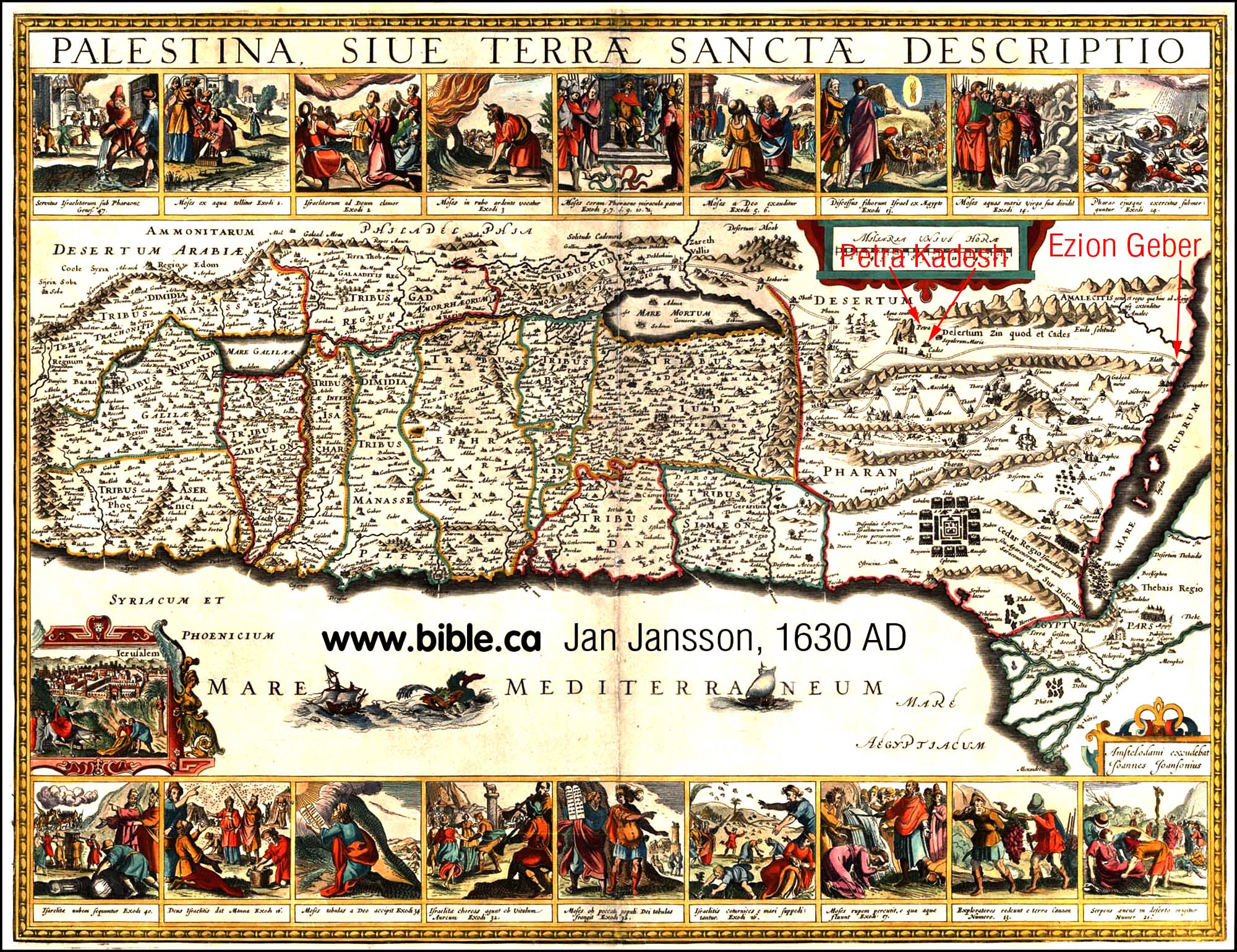
1630 AD: Jan Jansson
Sinai peninsula and Gulf of Aqaba
missing. Notice he has Ezion Geber on the Red Sea. Stop 32 is Ezion Geber, stop
33 is Kadesh, stop 34 is Mt. Hor. Both Kadesh and Hor are Transjordan. Kadesh
is at Petra. What is important, is that he placed Kadesh Transjordan before
he knew the location of Petra which was rediscovered in 1812 AD by
Burckhardt.
|
 |
|
|
|
|
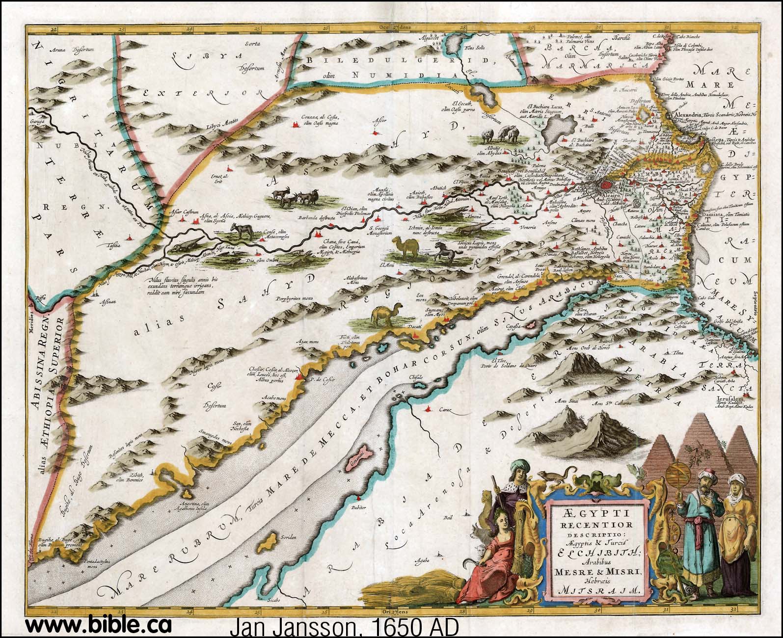
1650 AD: Jan Jansson
Sinai peninsula and Gulf of Aqaba
missing.
Mt. Sinai and Jerusalem are
shown, but not Kadesh.
|
 |
|
|
|
|
1650 AD: Thomas Fuller
Mt. Seir is transjordan, due east
of the Dead sea in Moabite territory.
|
 |
|
|
|
|
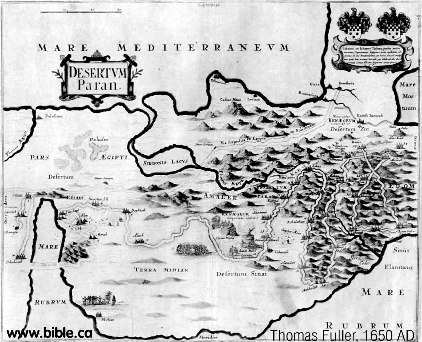
1650 AD: Thomas Fuller
The basic shape of the Gulf of
Aqaba is copied from Sebastian Munster's 1545 AD map. Kadesh Barnea is stop 33
and beside Petra. You can trace the standard exodus route map with numbering
system that has been around for hundreds of years.
|
 |
|
|
|
|
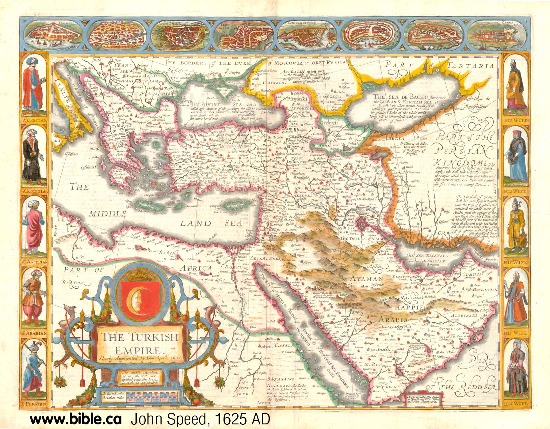
1651 AD: John Speed
The Gulf of Aqaba is copied from
Sebastian Munster's 1545 AD map. It is the standard exodus route of the day with
a transjordan
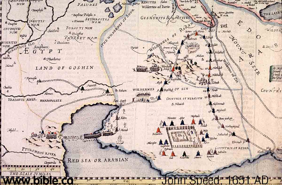 |
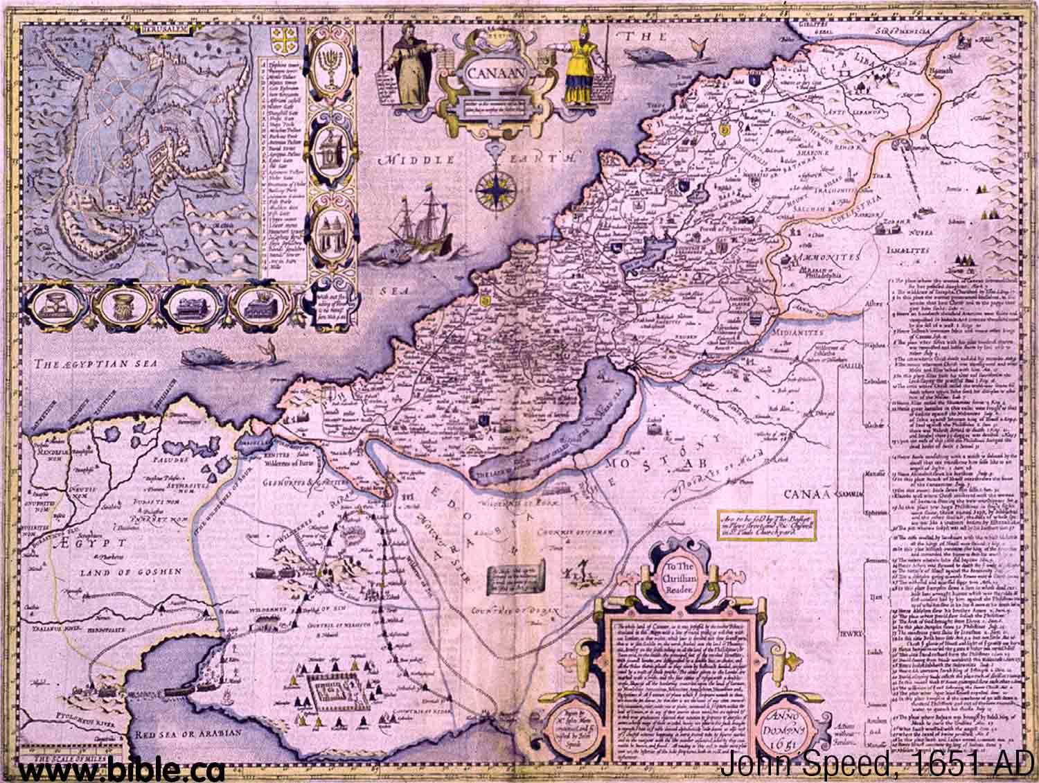
Kadesh a few stops after Ezion
Geber at Petra. Although Kadesh is beside Petra, the map is very inaccurate.
|
|
|
|
|
1651 AD: Philippe de La Rue
The shape of the Gulf of Aqaba is
copied from an early map by Sebastian Munster in 1545 AD.
|
 |
|
|
|
|
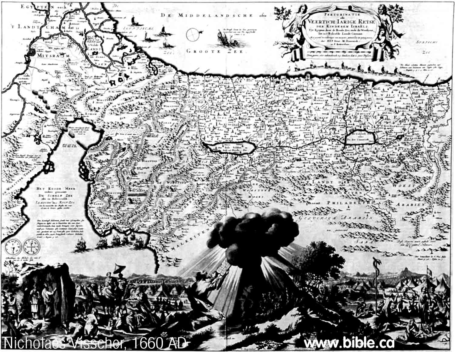
1660 AD: Nicholaes Visscher
The shape of the Gulf of Aqaba is
copied from La Rue (1651 AD) who in turn copied it from Munster (1545 AD).
The crossing point of the Red Sea is at the Port of Suez and the standard
exodus route map is used where stop 33 is Kadesh which is shown transjordan
just after Ezion Geber. Ezion Geber is where the ships are sailing to in a
row. This would also be Elat.
|
 |
|
|
|
|
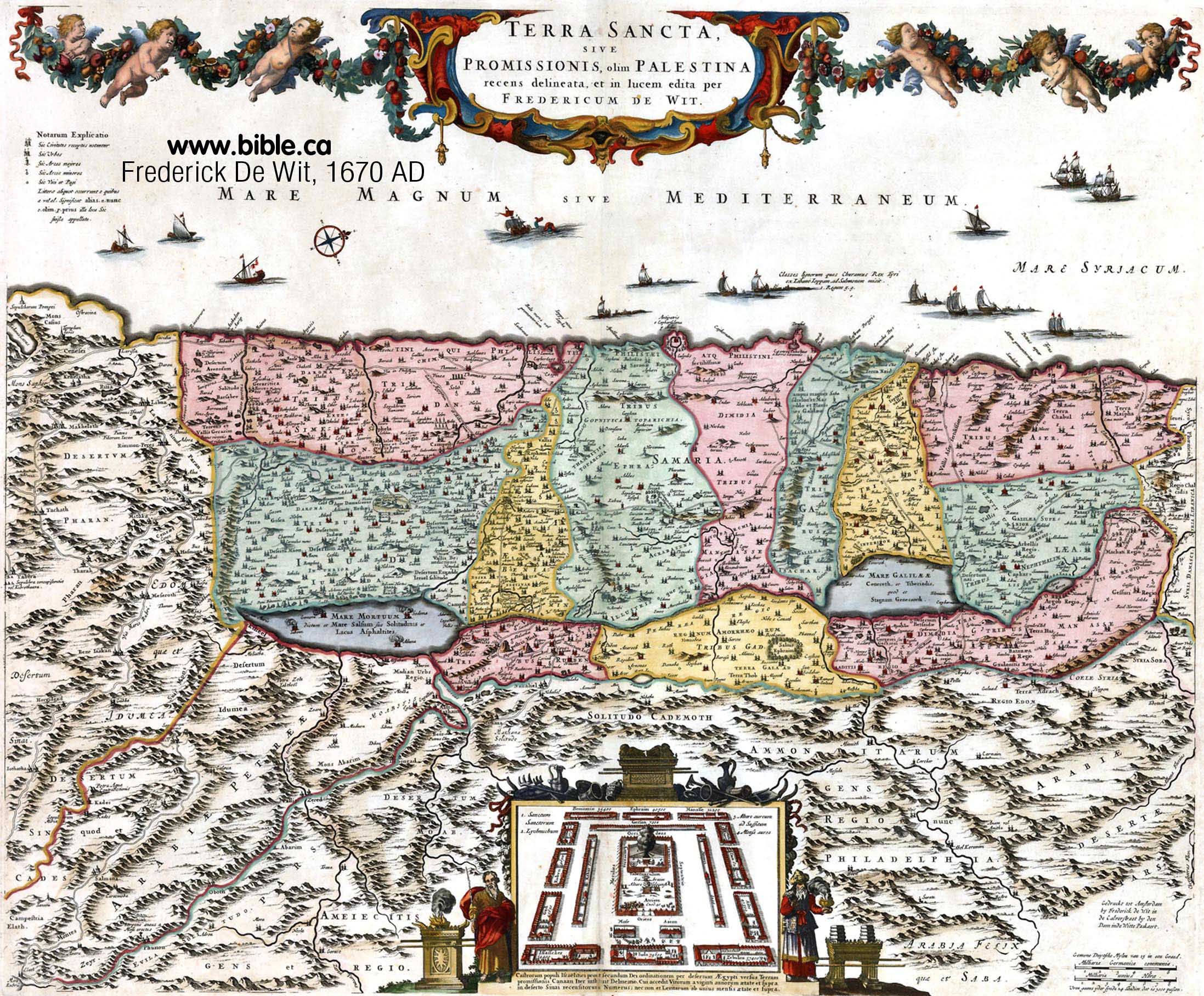
1670 AD: Frederick De Wit
Sinai is at the left hand edge of
the map botton third, below the Dead Sea. Kadesh Barnea is beside Sinai at
Petra.
|
 |
|
|
|
|
1671 AD: Joseph Moxon
Moxon almost exactly copies
Nicholaes Visscher's map of 1660 AD, who copied the shape of the Gulf of Aqaba
from La Rue (1651 AD) who in turn copied it from Munster (1545 AD). The
crossing point of the Red Sea is at the Port of Suez and the standard exodus
route map is used where stop 33 is Kadesh which is shown transjordan just
after Ezion Geber. Kadesh is at Petra. Ezion Geber (Elat) is where the ships
are in a row.
|
 |
|
|
|
|
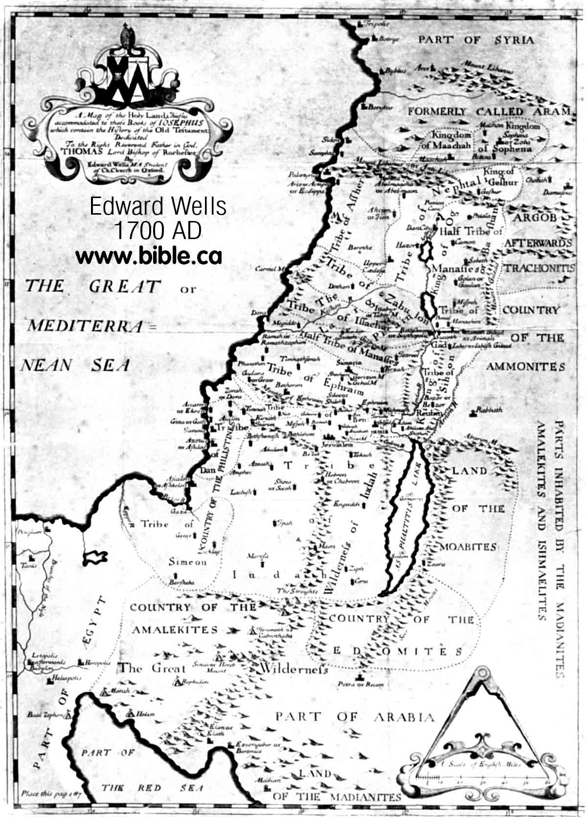
1700 AD: Edward Wells
Ezion Geber is east of Elat, in
Modern Jordan, which is correct. Modern maps incorrectly put Ezion Geber on
the west side of Elat, in modern Egypt. Midian is also correctly mapped on
the east side of the Gulf of Aqaba. Petra is correctly placed on the map
relative to the Dead Sea and the Gulf of Aqaba.
|
 |
|
|
|
|
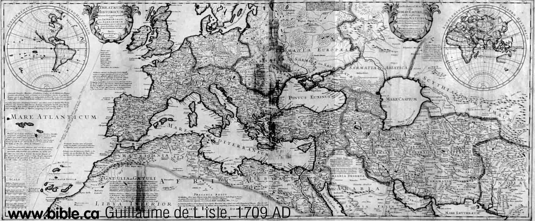
1709 AD: Guillaume de L'isle
The Gulf of Aqaba is beginning to
be understood a bit better, but this is really just an exaggerated version of
Munster's 1545 AD map and does not really offer anything new.
|
 |
|
|
|
|
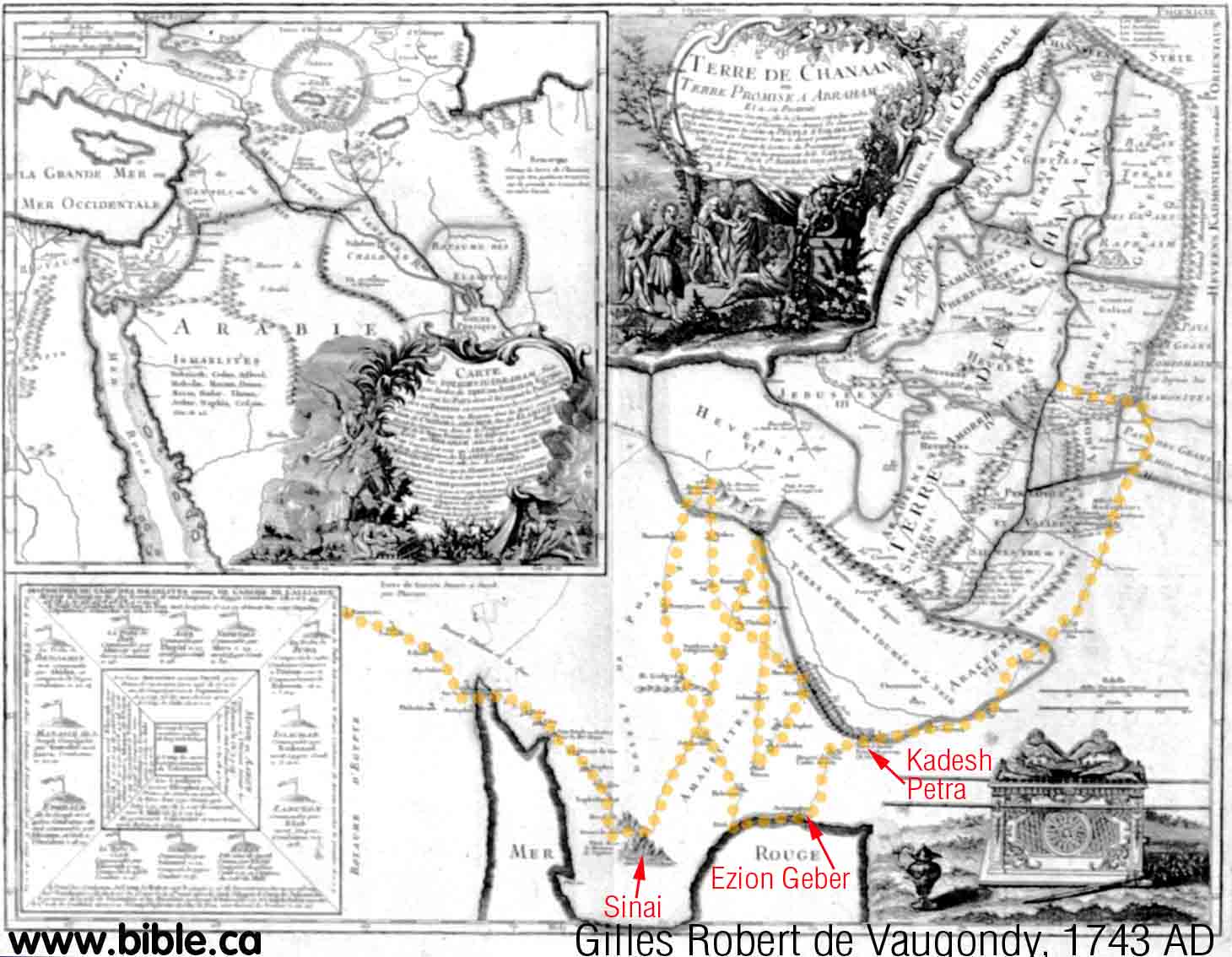
1743 AD: Gilles Robert de Vaugondy
Vaugondy's Gulf of Aqaba is not
well understood and is copied from Sebastian Munster's 1545 AD map. The
exodus route is hilarious. The yellow dotted line, we put on the map, traces
over Vaugondy route from Goshen. Notice it criss crosses itself many times!
Vaugondy had quite an imagination! However he still puts Kadesh transjordan
beside Petra, one stop after Ezion Geber. Compare his route with Emanuel
Bowen's in 1747 AD.
|
 |
|
|
|
|
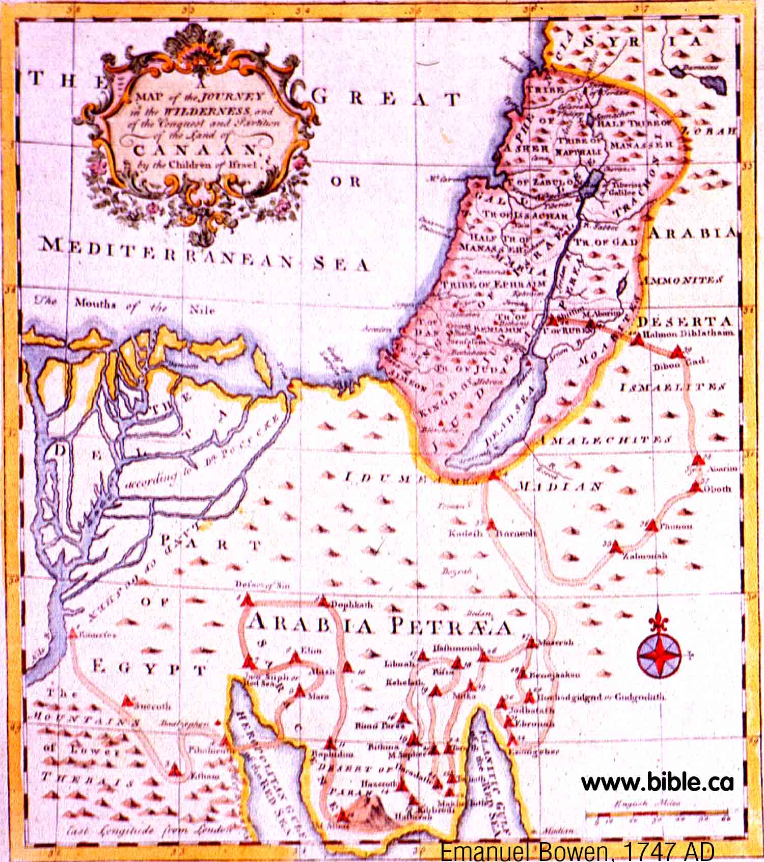
1747 AD: Emanuel Bowen
Bachiene should get an award for
giving us a much improved Gulf of Aqaba! Someone must have finally sailed the
Red Sea and brought back a new map with new information! Three years later
Bachiene (1759 AD) gave a similar version of this same shape. Note that Ezion
Geber is correctly mapped on the east side of the Gulf of Aqaba, Kadesh is
transjordan at Stop 33, one stop after Ezion Geber. Strangely, Petra is not
on the map.
|
 |
|
|
|
|
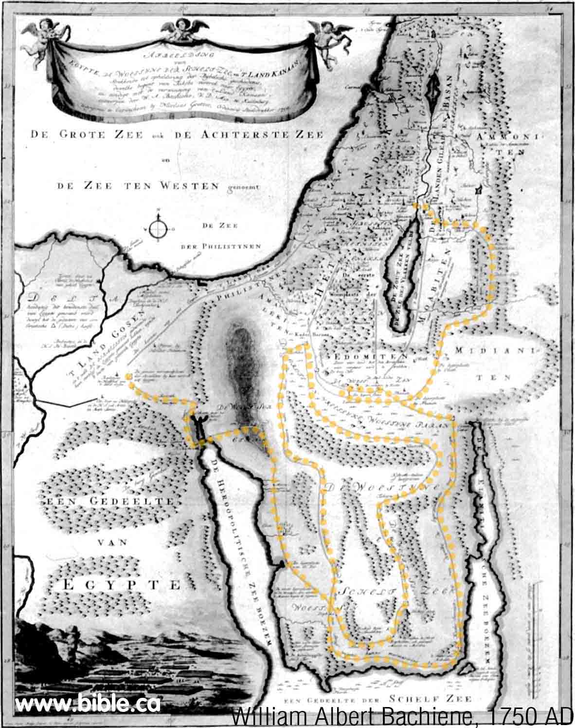
1750 AD: William Albert Bachiene
Here is another map that does a
much better job of drawing the two gulfs. The Sinai Peninsula is present and
the Gulf of Aqaba is quite close to correct. Kadesh is still transjordan at Petra.
However the route follows Vaugondy's 1743 AD criss cross pattern as seen on
the yellow dots we placed on the map. Out yellow dots trace over Bachiene's
route so it can be see easier.
|
 |
|
|
|
|
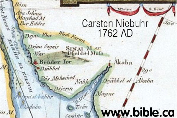
1762 AD: Carsten Niebuhr
This is the very first map to
name the correct crossing point of the Red Sea at the Straights of Tiran
by marking the Island of Tiran! It shows a crude Gulf of Aqaba. Here was the
actual crossing point of the Red Sea marked on a map and Niebuhr never knew
it! However, he viewed the north tip of the Gulf of Aqaba as a "forked
tongue". This forked tongue error is seen in Kitchin's 1794 AD map in
greater detail.
|
 |
|
|
|
|
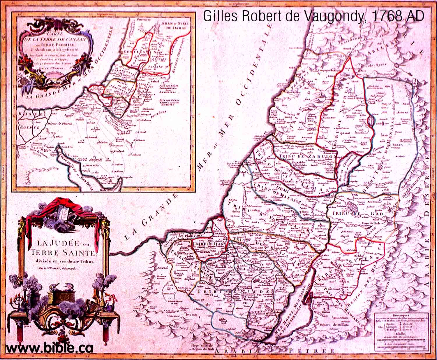
1768 AD: Gilles Robert de Vaugondy
You can see in the little inset
map that the Gulf of Aqaba is still not understood. This was probably copied from
Carsten Niebuhr's map of 1762 AD.
|
 |
|
|
|
|
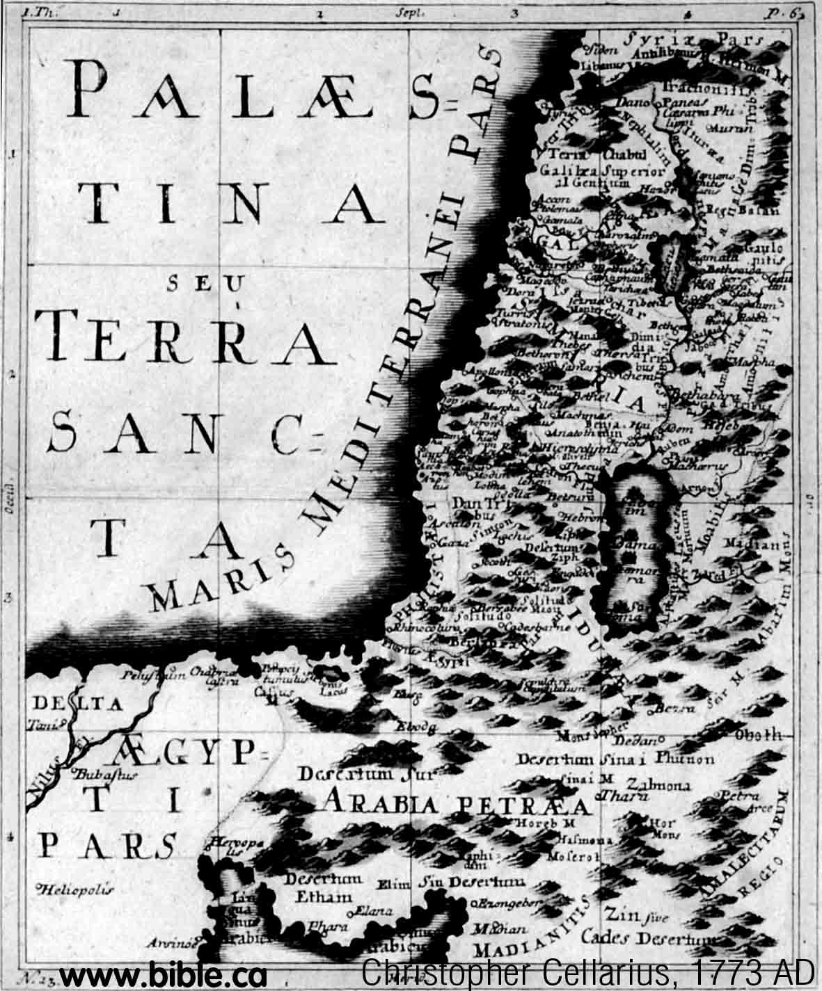
1773 AD: Christopher Cellarius
This is a new variation of the
shape for the Gulf of Aqaba that was first invented by Sebastian Munsters 1545
AD. However, this unique shape is copied during into many maps in the 1700's.
Ezion Geber is seen to be on the east side of the Gulf of Aqaba. Kadesh is
transjordan at Petra and the Midianites are in Arabia.
|
 |
|
|
|
|
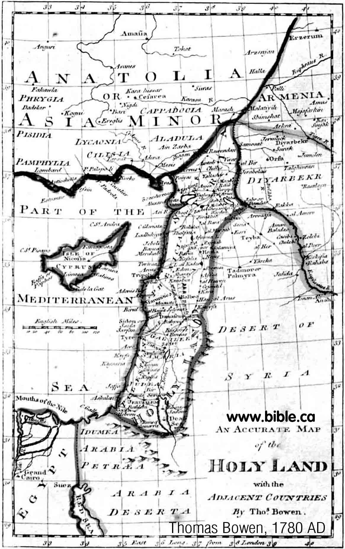
1780 AD: Thomas Bowen
Bowen greatly exaggerates the
forked tongue seen in Carsten Niebuhr's 1762 AD map. The Gulf of Aqaba looks
like a hand puppet of a cute African Basenji named "Tuli the
Sentinel"!
|
 |
|
|
|
|
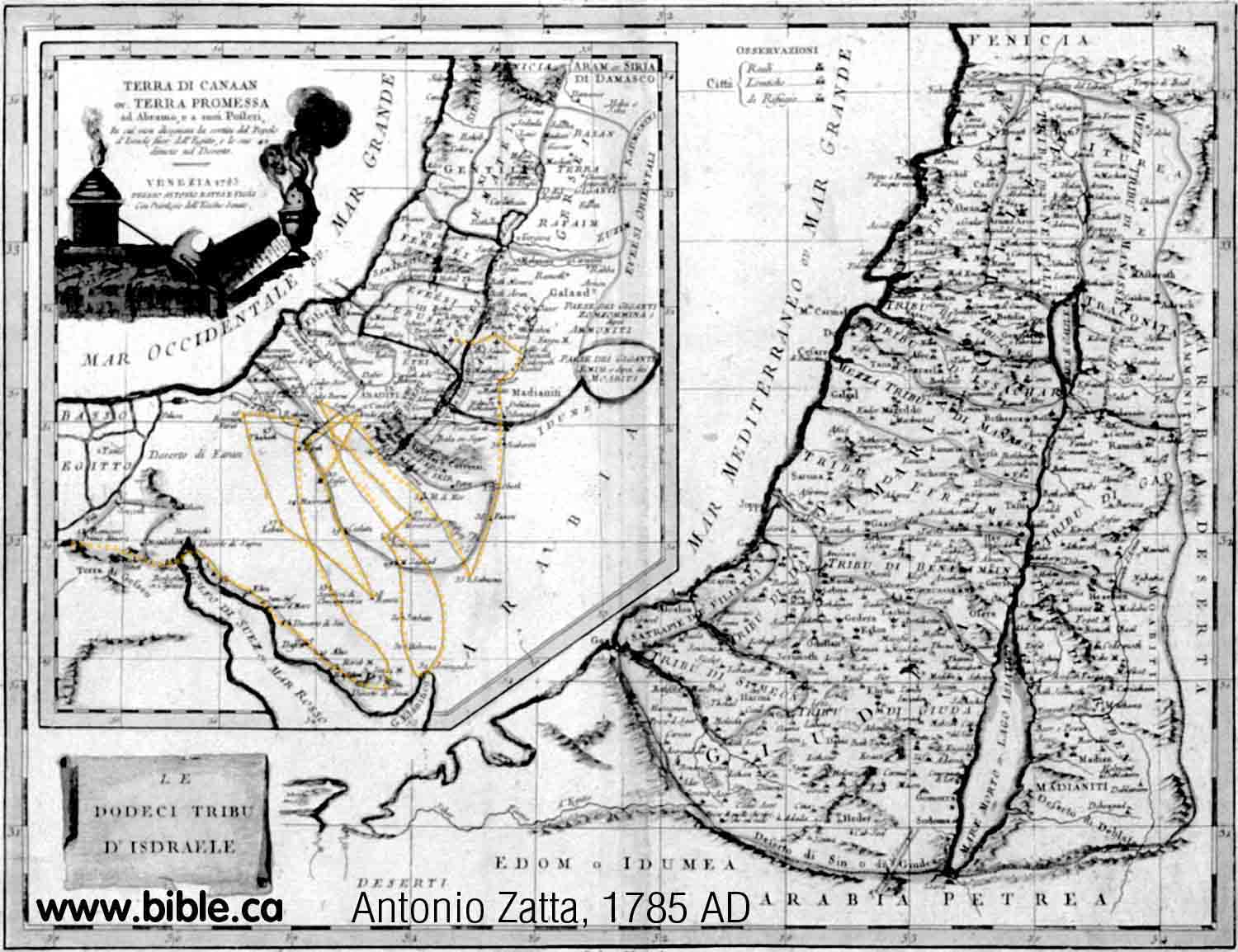
1785 AD: Antonio Zatta
The shape of the Gulf of Aqaba is
similar to the 1650's. The general exodus route on this map continues the
long tradition of putting Kadesh transjordan at Petra at stop 33. This was
one stop after Ezion Geber. The route is the most bizarre example of the Zig
Zag, criss cross we have found. We put yellow dots on top of Zatta's route.
|
 |
|
|
|
|
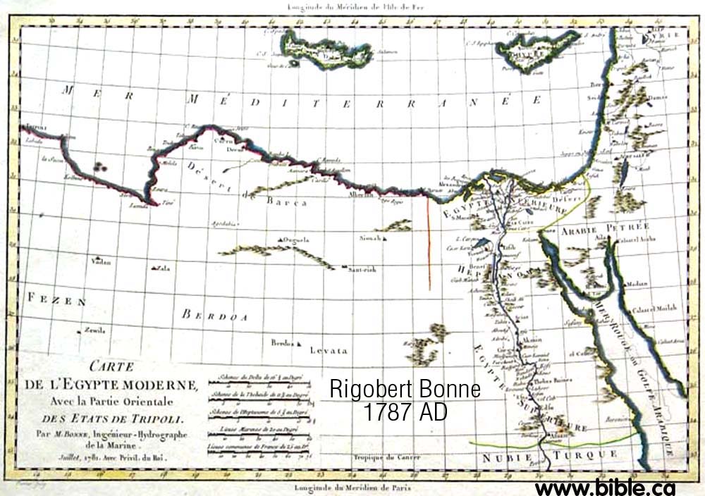
1787 AD: Rigobert Bonne
Notice how the forked tip of the
Gulf of Aqaba is given greater detail. Midian is correctly placed in Arabia
at Al Bad.
|
 |
|
|
|
|
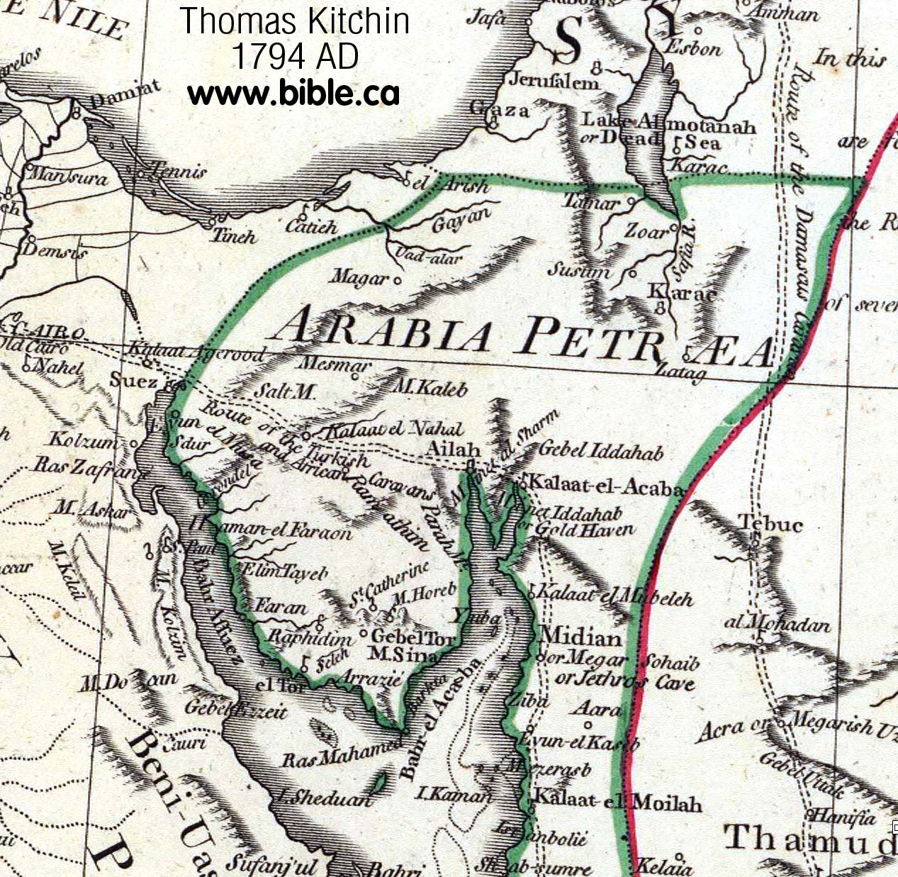
1794 AD: Thomas Kitchin
The "forked tongue" of
the Gulf of Aqaba is given in great detail. All of this was imagination!
Having personally been several times to modern Elat, it is clear the northern
tip has no such feature. Although he places Mt. Sinai inside the Sinai
Peninsula, he knew that Midian (Jethro's cave) was in modern North Saudi
Arabia.
|
 |
|
|
|
|
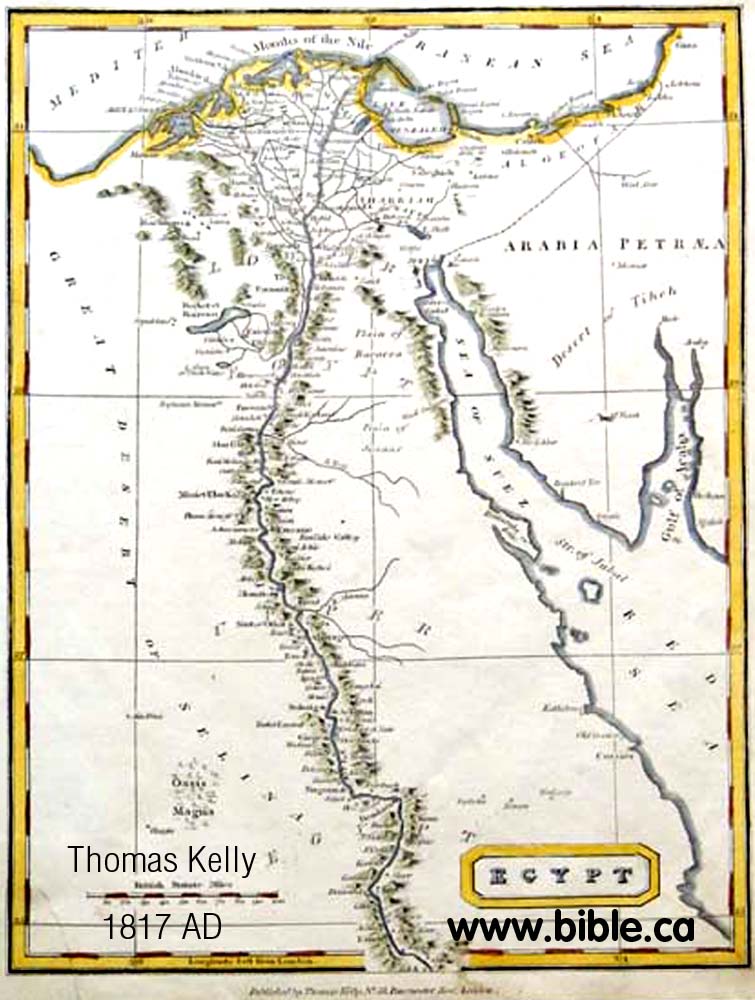
1817 AD: Thomas Kelly
This is probably the last map that
showed the fork at the end of the Gulf of Aqaba before the discovery of the
Arabah valley and Petra by Johann Burckhardt in 1822 AD.
|
 |
|
|
|
|
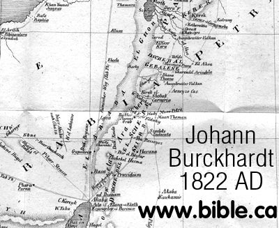
1822 AD: Johann Burckhardt
Burckhardt himself observed:
"The existence of the valley El Araba appears to have been unknown both
to ancient and modern geographers, although it forms a prominent feature in
the topography of Syria and Arabia Petræa. It deserves to be thoroughly
investigated."
|
 |
|
|
|
|
1841 AD: Edward Robinson
In 1831, Karl Von Raumer's chose
Ein Hasb for Kadesh Barnea, but this was rejected by Robinson in 1841 AD who
placed Kadesh at Ain Weibeh
just a few km south. News of Petra's discovery opened up a new world of
exploration in this area. Click here
for more discussion and maps of Ein Hasb and Ain Weibeh.
|
 |
|
|
|
|
1849 AD: Carl Radefeld
Radefeld made an error by not going
through Ezion Geber between Sinai and Kadesh. The gulf of Aqaba and the Sinai
Peninsula was not understood or mapped until about 1750 AD. This map is very
interesting because it shows Kadesh at Ain Weibeh.
In 1838 Edward Robinson chose Ein El Weibeh for Kadesh. Here is a map that
shows Kadesh at Weibeh in the time historical time period when this is where
the world thought it was. Notice this is not tranjordan, but just north of Petra
on the west side of the Arabah Valley. But Mt. Hor is at Petra and near
Kadesh.
|
 |
|
|
|
|
1881 - 1916 AD: Ein Qedeis
In 1842 AD John Rowlands was the
very first man in history to suggest Ein
Qedeis was Kadesh Barnea. Not many took notice of this until the
deceptive account of Qedeis published by Henry Clay Trumbull in 1884 AD. In
1881 AD: Clay Trumbull visited Ein Qedeis for only
one hour, and then wrote an article in 1884 AD that formally stated
that it was Kadesh Barnea.
John Rowlands goes down in
history as the man who plunged the search for Kadesh Barnea in to the
"Dark Ages" (1881 AD - present). But Ein Qedeis would be just
another desert spring without Henry Clay Trumbull who is responsible for
literally deceiving the entire world into believing it was Kadesh Barnea. The
"one-two punch" of Rowland-Trumbull moved the worlds attention for
the location of Kadesh from the Transjordan Arabah to where it has been
presently located on all Bible maps since 1916 AD.
|
 |
|
|
|
|
1916 AD
In 1916 AD In 1914, Woolley and
Lawrence excavated Qudeirat and declared it to be Kadesh Barnea. Since they published
their work in 1916 AD down to the present time, almost every map in the back
of every Bible places Kadesh Barnea at Ein
el-Qudeirat. This is most unfortunate for a number of reasons, mainly
because it is inside the promised land.
Here is a map with all the
various locations for Kadesh Barnea including ein Hasb, ein Weibeh, ein
Qedeis and ein Qudeirat.
|
 |
|
|
|
|
Today!
The ancient Exodus Route has been
restored to what Moses understood and scripture reveals.
We invite you to consider the
crossing of the Red Sea at the Straits of Tiran,
Mt. Sinai at Mt. Lawz and
Kadesh Barnea at or
just north of Petra.
See also: The Chronological
History of "The search
for Kadesh"
|
 Satellite map |
|
|
|
Conclusion:
- The reason no one, until recently, has proposed a crossing of the Red Sea at the Gulf of Aqaba, is because no one before 1750 even knew it existed! Remember that even today information moves slowly. It really wasn't until about 1800 before the Gulf of Aqaba became widely shown on maps in every country.
- When the Gulf of Aqaba first appeared in 1750-1800 AD, explorers focused on the location of Kadesh Barnea, not Mt. Sinai or the crossing point of the Red Sea. It has only been in the last 75 years that the Gulf of Aqaba has been considered a crossing point, which of course forces Mt. Sinai to be in Saudi Arabia... just as Paul said.
- From 325 - 1900 AD almost all exodus route maps crossed the Red Sea at the port of Suez, placed Mt. Sinai where Queen Helena saw it in a dream and Kadesh at Petra. They got Sinai wrong and Kadesh right! Recently, some have proposed a crossing on the Gulf of Aqaba, a Mt. Sinai in Saudi Arabia and a Kadesh Barnea inside the promised land at Qudeirat. These got Mt. Sinai right but Kadesh wrong! It is time to restore Kadesh back to the Petra area, cross the Red Sea at the Gulf of Aqaba and place Mt. Sinai in Arabia!
- Many rather obvious error and misunderstandings of geography have prevented the discovery of the exodus route. Not knowing about the existence of the Sinai Peninsula or the Gulf of Aqaba until 1750 - 1800 AD, prevented mappers from even considering a Red Sea crossing on the Gulf of Aqaba and a Mt. Sinai located in North Saudi Arabia.
- Everyone from the time of Josephus down to 1831 believed Kadesh Barnea was at or near Petra.
- A lack of proper respect for the scriptures as a trump card over the "archeology of the day" is seen in the many unfortunate choices for Kadesh since 1831 AD down to the present. Kadesh simply cannot be located at the springs of Harb, Weibeh, Qedeis or Qudeirat, because they are inside the promised land of Judah.
- A misreading of how to draw the southern border of Judah in relation to Kadesh Barnea has also been a huge problem. The scriptures clearly show Kadesh to be Transjordan.
- See: The Exodus route proven from the Bible.


Comments
Post a Comment