FAKTA PARAN, GUNUNG SINAI BERADA DI KAWASAN ARABIA (TEK INDONESIA)
Bukan rahasia lagi bahwa Paran (Arabia Al-hijaz) dan Gunung Sinai (arabia barat) di dalam peta-peta modern sekarang digambarkan jauh dari keadaan geografisnya hingga menjauh dari kawasan arabia? terutama dalam peta-peta kristen yang tidak jujur pada fakta sejarah, Paran dan gunung sinai kadang di letakan di sebelah barat di seberang teluk Aqaba, ada apa?yuk kita lihat berdasarkan kajian sejarah mengapa bisa begitu [[mohon maaf ada sebagian teks lagi belum saya terjemahkan kedalam bahasa indonesia hehe, tapi saya yakin para pembaca englishnya pada pintar di banding saya :v ]]

Contoh diatas adalah peta yang keliru mengenai Gunung sinai yang saya ambil dari salah satu website kristen, yuk kita bahas mengenai sejarah peta yang sebenarnya menurut para ahli, dan peta diatas diambil berdasarkan hipotesis siap 1. Hesiod sorang penyair yunani (700 BC)
Perhatikan peta karya beliau berikut:
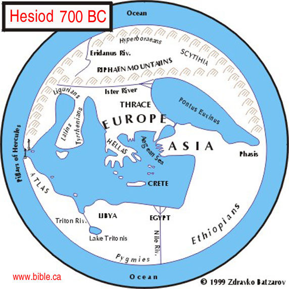
Peta ini merupaka peta paling modern saat 700 SM mengenai letak Timur tengah, namun sayangnya beliau tidak mempunyai pengetahuan yang memadai, dimanakah letak laut merah, israel dll
2. 520 BC: Hecataeus (seorang filsuf yunani)
Perhatikan:
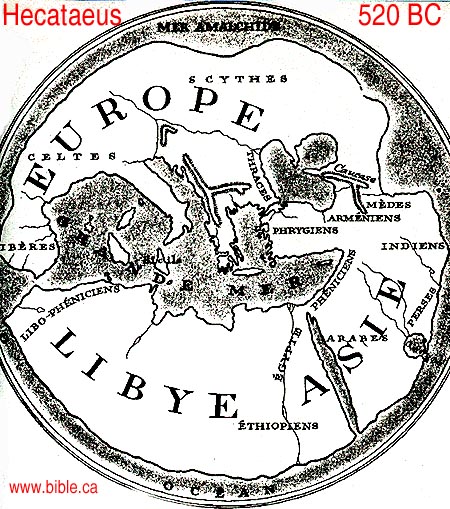
Ini adalah peta modern kedua timur tengah, yang di buat oleh Hecataeus, beliau melanjutkan karya Hesiod, Hecataeus mempunyai pemahaman yg lebih baik yakni beliau mencantumakn israel tapi laut merah tidak
3. 484 BC: Herodotus
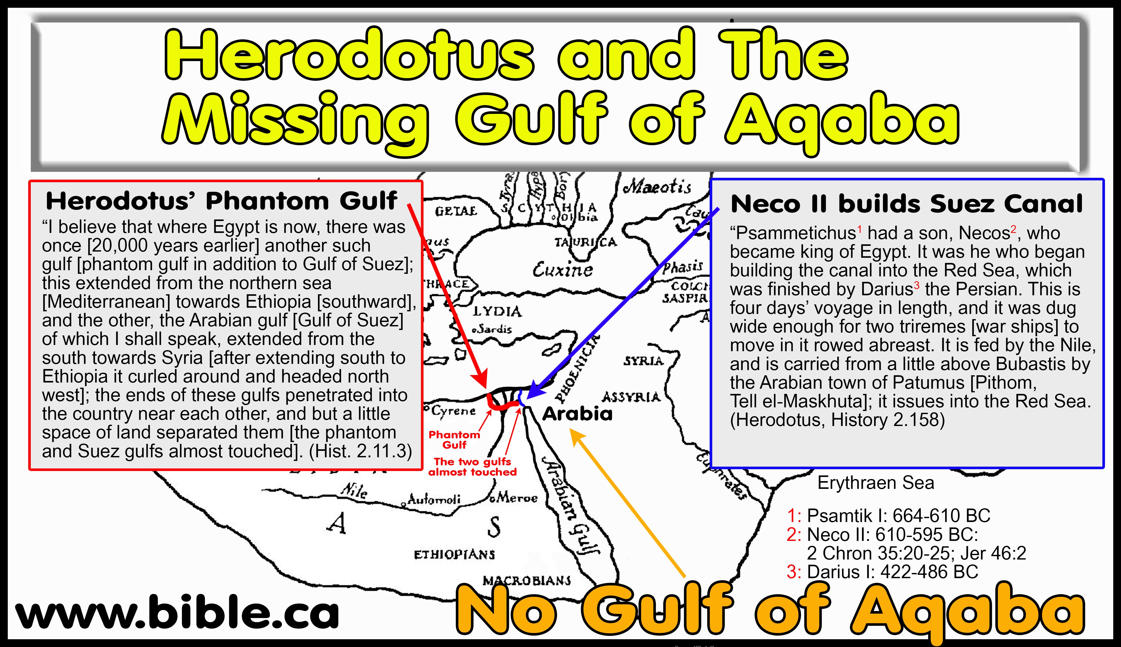
Peta modern berdasarkan interpretasi langsung Herodotus tahun 500 SM, dalam peta beliau tidak ada konsep Teluk aqaba, melainkan hanya lekukakan aneh mirip lidah dibagian atas teluk suez, kedua teluk menjorok kedarat sehingga hampir bertemu satu sama lain dan menyisakan diantara keduanya sebuah saluran sempit
4. 250 SM BERDASARKAN SEPTUAGINTA LXX
Septuaginta LXX, menterjemahkan Kitab kejadian 45:10; 46:34 sebagai , "Goshen of Arabia".
Tahun 250 SM suatu bukti bahwa sebelum rasul paulus menulis Galatia 4:25, bahwa segala sesuatu yang berada disebelah timur Sungai Nil di anggap Arabia, kitab septuaginta hanya mencerminkan pemahaman geografis saat itu, tidak punya konsep dimana letak Semenanjung sinai dan teluk aqaba, para penterjemah Septuaginta hanya menyalin errors dari ahli geografi modern saat itu,karena terbukti tidak ada dalam Teks alsi ibraninya
Beliau pernah tinggal dan melakukan research di Alexandria mesir, sehingga beliau bisa mengakses semua arsip2 perpustakaan di sana, beliau dengan pasti menempatkan Paran berada di kawasan arabia (al-hijaz) dan gunung Sinai berada di arabia Barat dekat madyan, dalam karya beliau berjudul PREAPARATIO EVANGELICA 9:29.1-3 seperti yang pernah dikutip oleh Eusebius
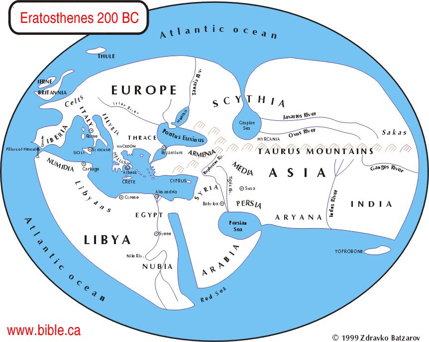
6. Eratosthenes (200 SM)
Eratosthenes hanya menyalin kesalahankesalahan geogarfis seperti pendahulunya Herodotus, Hecataeus, Hesiod
7. Agatharchides (169 SM)
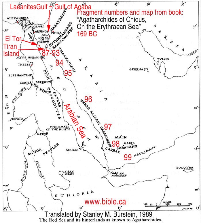
Agatharchides satu-satunya ahli geografi sebelum 1800 AD yang unik, beliau mengerti akan letak teluk Aqaba yang beliau sebut " TELUK LAEANITES " beliau tidak berlayar jauh menuju teluk aqaba tetapi beliau mengatakan orang2 arab tinggal di timur pantai bukan disebelah kirinya dan itulah akhir teluk yakni Petra
8. Kitab Jubilees (150 SM)
Dalam kitab jubilee pasal 8:10-30 dengan jelas di sebutkan bahwa paran dan Gunung sinai benar-benar di kawasan arabia, dalam kitab ini kawasan arabia adalah tanah perjanjian dan tanah di berkahi bagi Shem, anak2nya dan keuturunannya yang kekal dari generasi ke generasi, dan sebagai gen eden (Taman surga bumi seperti di gambarkan dalam kitab Kejadian) dan sebagai pusat Bumi (centre of earth)
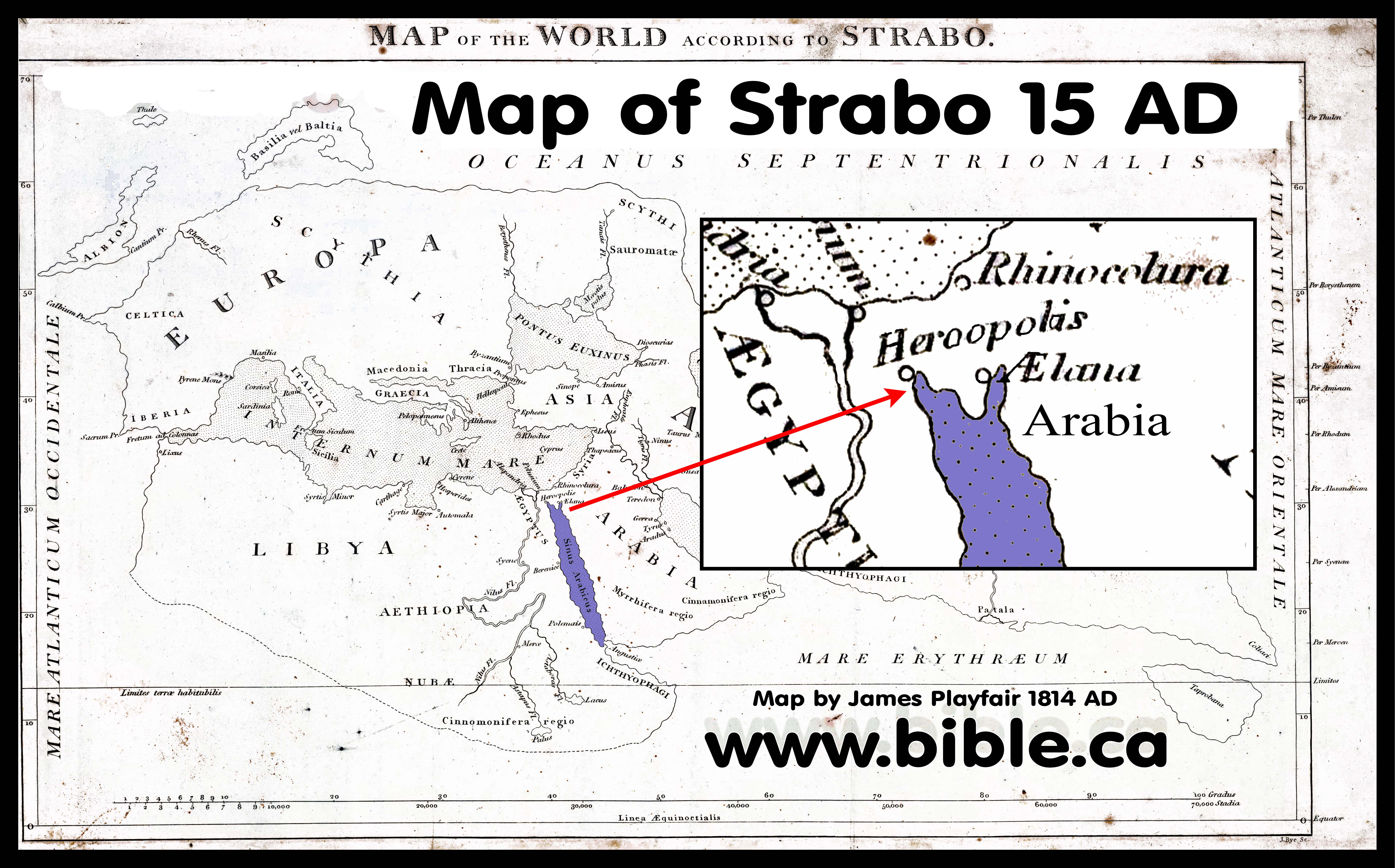
9.AD: Strabo (15 AD)
Beliau menggambarkan laut merah tak ubahnya seperti sebuah jari dan tidak punya konsep pemahaman mana teluk Aqaba dan semenanjung sinai
10. 45 AD: Apion
11. Philo of Alexandria (50 AD)
Philo menolak jalur penyeberangan musa di laut merah baik dari Bitter lakes maupun ujung utara teluk Suez yang pada gilirannya beliau juga menolak letak tradisional gunung sinai persis seperti apa yang di mimpikan oleh ibunya konstantine di tengah tengah semenanjung sinai, Philo menggunakan Arab/Arabia hanya terbatas kepada daratan sebelah timur teluk aqaba dimana Jetro (nabi Ayub) dan orang-orang ismael tinggal, Philo tidak pernah mengatakan jazirah sinai di arabia.
12. 110 AD: JOSHEPUS (110 AD)
Josephus believed that Mt. Hor
was at Petra. Josephus echoed Philo's belief that Mt. Sinai was "the
highest of the mountains" in the region. Josephus refers to Petra as the
capital of Arabia, proving he wrote after 106 AD when Petra was annexed by
the Romans and named this. Josephus' account of the exodus has been stripped
of all geographic markers.
Joshepus mempercayai bahwa gunung Hor berada di Petra, Joshepus mengimani apa yang di utarakan oleh Philo bahwa gunung sinai merupakan Gunung tertinggi di daerah itu, Joshepus merukuk petra sebagai ibu kota Arabia dan Petra di caplok oleh romawi pada tahun 106 AD, Joshepus juga telah melucuti segala penanda geografis peristiwa exodus musa.
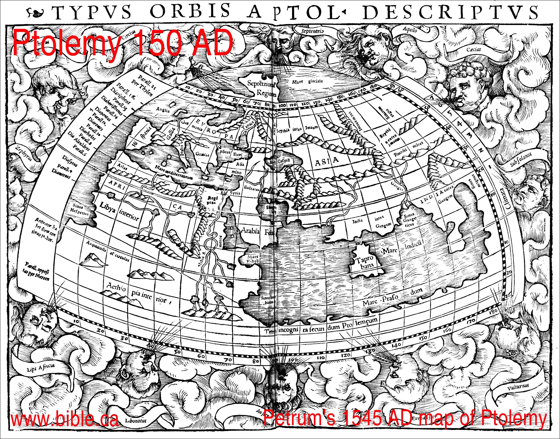
13. PTOLEMY 150 AD
Beliau tidak mempunyai konsep diman semenanjung sinai dan Teluk suez dalam petanya
14. Justin Martyr ( 165 AD)
Justin said, "while he was tending the flocks of his maternal uncle in the land of Arabia, our Christ conversed with him under the appearance of fire from a bush"
Beliau mengatakan ketika saya sedang menggiring kawanan ternak pamannya dari garis ibu di dataran arabia Tuhan berbicara di bawah semak berbentuk api
15. (180 AD) Clement
Clement said the Phoenix had its
origin in "Eastern lands, that is, in Arabia", far away from Egypt.
This indicates that the Sinai Peninsula was not viewed by Clement as Arabia.
|
|
16. (325 AD) Eusebius, The Onomasticon
|
Eusebius said that Kadesh Barnea
& Mt Hor were at Petra. He also said that the Mt. Sinai, the wilderness
of Paran and Wilderness of Shur were all Transjordan. Eusebius echoes Gen
15:18, that the Wadi el-Arish is the border between Egypt and Israel. This
means that the Sinai peninsula was part of Egypt, according to Eusebius.
|
17. (381 AD) Egeria
|
The Diary of Egeria is not
helpful in locating Mt. Sinai, since she was merely going to the place Helena
chose in a vision a few years before.
|
18. (400 AD) Jerome
|
Jerome held the same views of
geography that Eusebius did. Jerome was used as a resource in making the
Madaba Map.
|
19. 550 AD: The Madaba map
Missing entirely from the Madaba Map
is the Red Sea, Mt. Sinai and Petra/Kadesh Barnea. It would certainly be on
the map, but was vandalized by the Muslims in 700 AD. Most notably, however,
is that the modern choice for the location of Kadesh Barnea at Ein
el-Qudeirat, should be in a section of the map that is fully intact.
Qudeirat should be located close to the large red text, "lot of
Simeon". This means that Kadesh is located in one of the damaged areas
and proves Kadesh is not at Qudeirat. The Madaba map was based upon the
Onomasticon by Eusebius, and Jerome.
More: The Madaba map, 542 AD
|
 |
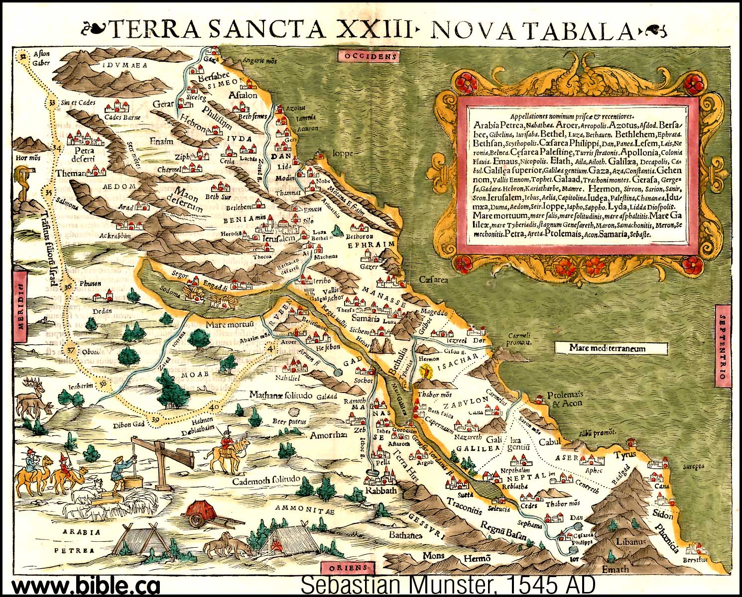
20. (1545 AD) Sebastian Munster
This is the first modern map we
have found. It is obvious that this basic map had been in existence for a long
time before. With the advent of the printing press, it suddenly appears all
over the world in different countries. You will notice that the practice was
to have a standard numbering system for each of the 40+ stops of the exodus.
Stop 33 is Kadesh, stop 34 is Mt. Hor. Both Kadesh and Hor are Transjordan
and east of Petra.
|
 |
21. (1545 AD) Sebastian Munster
Notice that there is a crude
representation of the Gulf of Aqaba. However, in a later map Munster does not
show the Gulf of Aqaba at all. Kadesh would be considered transjordan. See
his detailed map above.
maps-bible-archeology-exodus-route-kadesh-barnea-gulf-of-aqaba-sinai-peninsula
|
 |
22. (1579 AD) Cornelis De Jode
Sinai peninsula and Gulf of Aqaba
missing and viewed as a single finger of water.
Mt. Sinai and Kadesh are
transjordan.
|
 |
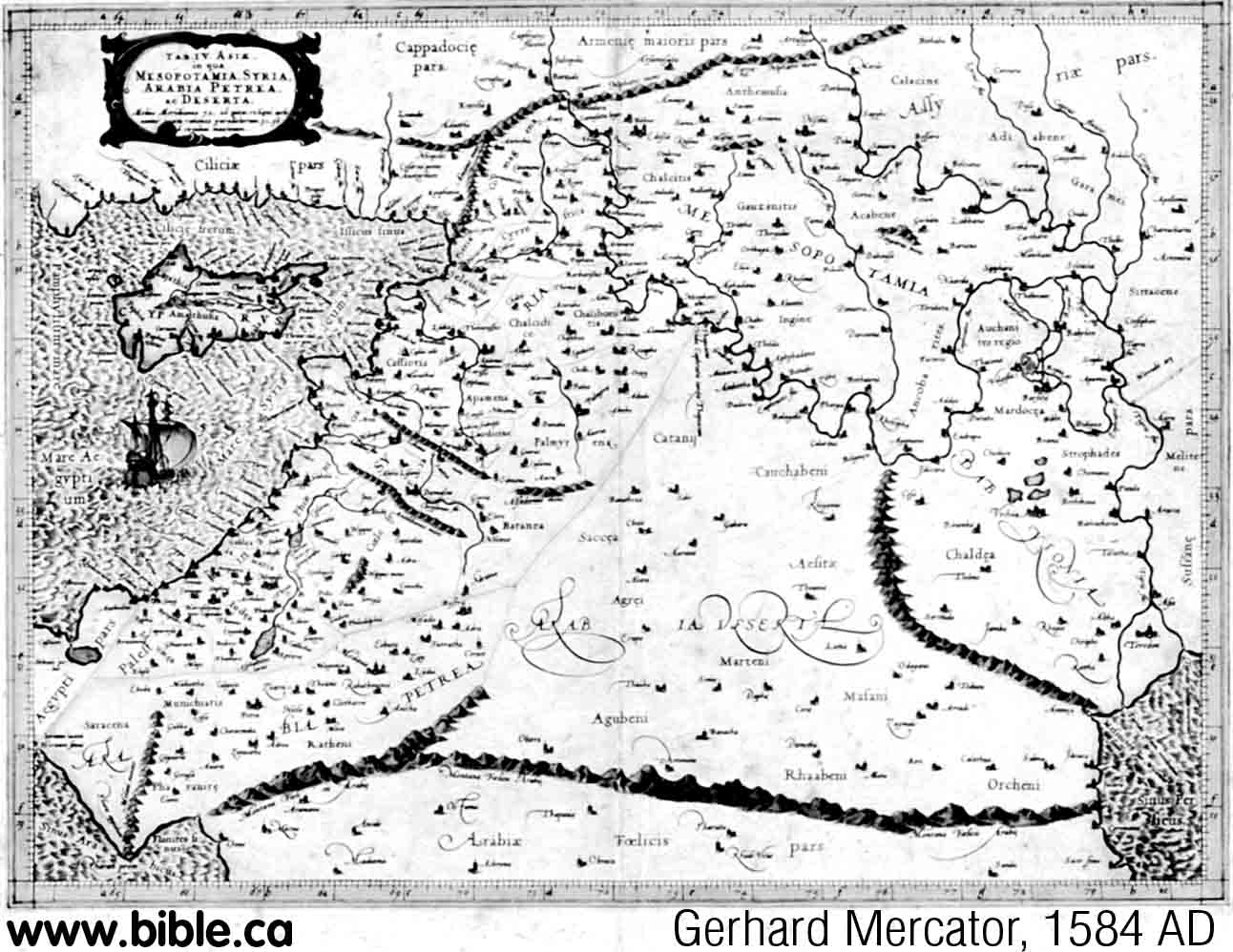
23. (1584 AD) Gerhard Mercator
This map was copied from
Sebastian Munster's 1545 AD map. Interesting that at the time Mercator drew
this map, Munster four years later, drew a map that had no concept of the
Gulf of Aqaba in 1588 AD. (see below)
|
 |
24. (1587 AD) Abraham Ortelius
Sinai peninsula and Gulf of Aqaba
missing. This is a typical exodus route map with standardized numbering
system. Crossed the Red Sea at the gulf of Suez. Stop 33 is Kadesh, stop 34
is Mt. Hor. Both Kadesh (Cades) and Hor are Transjordan and east of Petra.
But the map is a mess. There are two Petra's and two Kadesh's. Eusebius
speaks of two Kadeshes (Cades). The second Petra is left of stop 25. The
second Kadesh is right of stop 26. In Hebrew Questions on Gen 14:7, Jerome
says "Cades is a place near Petra called the spring of judgment where
God judged the people"
|
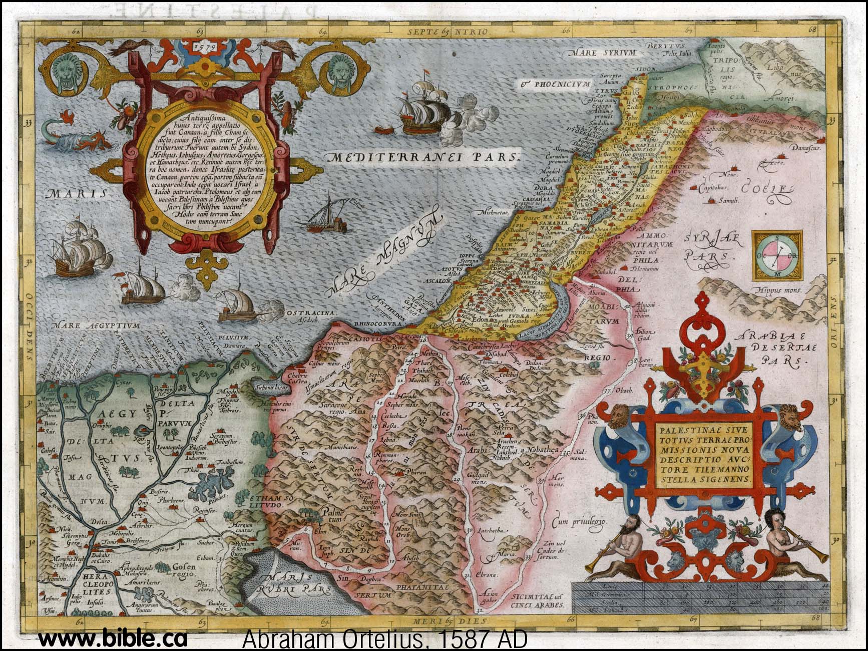
What is
important, is that Ortelius placed Kadesh Transjordan before he knew the
location of Petra which was rediscovered in 1812 AD by Burckhardt.
|
25. (1588 AD) Sebastian Munster
Although Munster showed a crude
representation of the Gulf of Aqaba on an earlier map, here he has no concept
of the Gulf of Aqaba. It is most likely that Munster was influenced by Abraham
Ortelius who always drew the Red Sea as a single finger of water.
|
 |
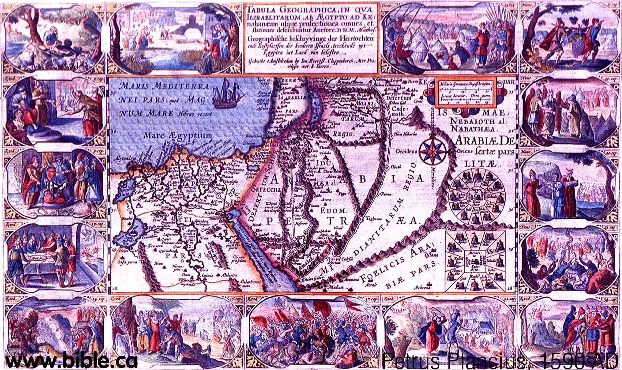
26. (1590 AD) Petrus Plancius
This is one of the few maps that places
Ezion Geber on the Red Sea when the Gulf of Aqaba is missing. Kadesh is stop
33 of the exodus route and is transjordan. The section between Sinai and
Ezion Geber is very wrong, but this is typical of all exodus route maps when
their basic geography was so wrong.
|
 |
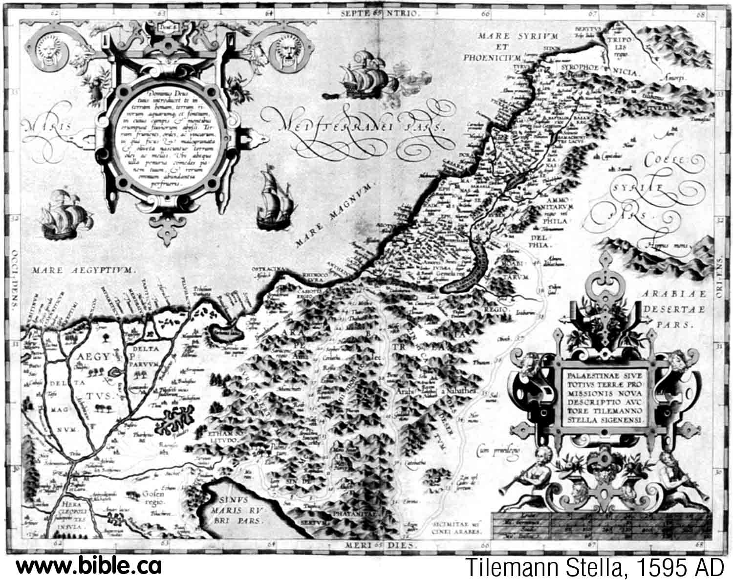
27. (1595 AD) Tilemann Stella
This is almost an exact copy of
an earlier map done by Abraham Ortelius in 1587 AD. No concept of the Gulf of
Aqaba and Kadesh is transjordan.
|
 |
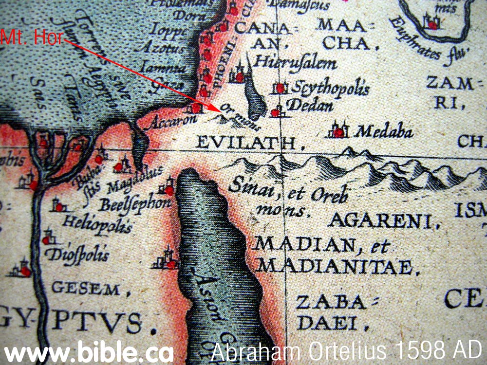
28. (1598 AD) Abraham Ortelius
Sinai peninsula and Gulf of Aqaba
missing
Whole map and close up Israel below.
Ortelius seems to have dominated
the geography of the day. Although Sebastian Munster has shown a crude Gulf
of Aqaba in 1545 AD, he removed any trace of the Gulf of Aqaba in later maps
in 1588 AD. It is clear that Sebastian Munster was influenced by Abraham
Ortelius to wrongly draw the Red Sea as a single finger of water, completely
ignoring the Gulf of Aqaba. However, about 30 years later, (1629 AD) Willem
Blaeu must have picked up some of Sebastian Munster's earlier maps and
included the crude representation of the Gulf of Aqaba.
|
  |
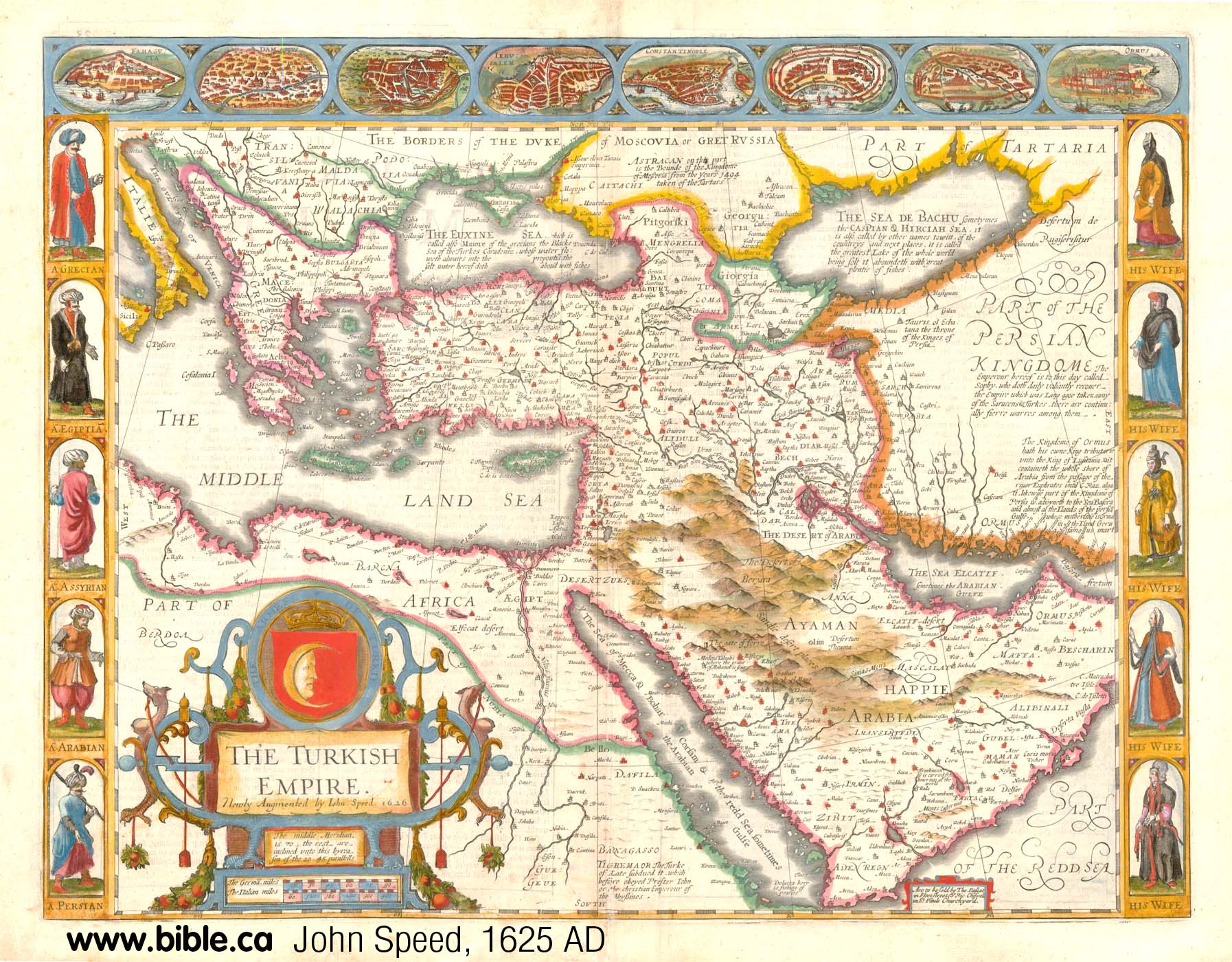
30. (1626 AD) John Speed
Sinai peninsula and Gulf of Aqaba missing. Whole map and close up Israel below. 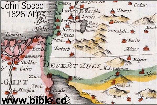 |
 |
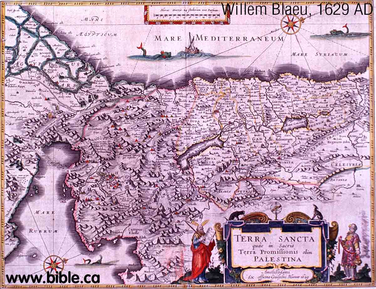
31. (1629 AD) Willem Blaeu
Blaeu is copying from Sebastian
Munster's 1545 AD map. Different parts of the world used different maps. The
Gulf of Aqaba is not understood well, but at least it has "sprouted on
the tree"! Ezion Geber is not on the map. Notice the natural land bridge
represented at the top of the Gulf of Suez. There is a natural land bridge
here, but not as shown here.
|
 |
32. (1630 AD) Jacobus Tirinus
The Sinai Peninsula and the Gulf of
Aqaba are non-existent. Ezion Geber is on the Red Sea and one stop before
Kadesh which is transjordan.
|
 |
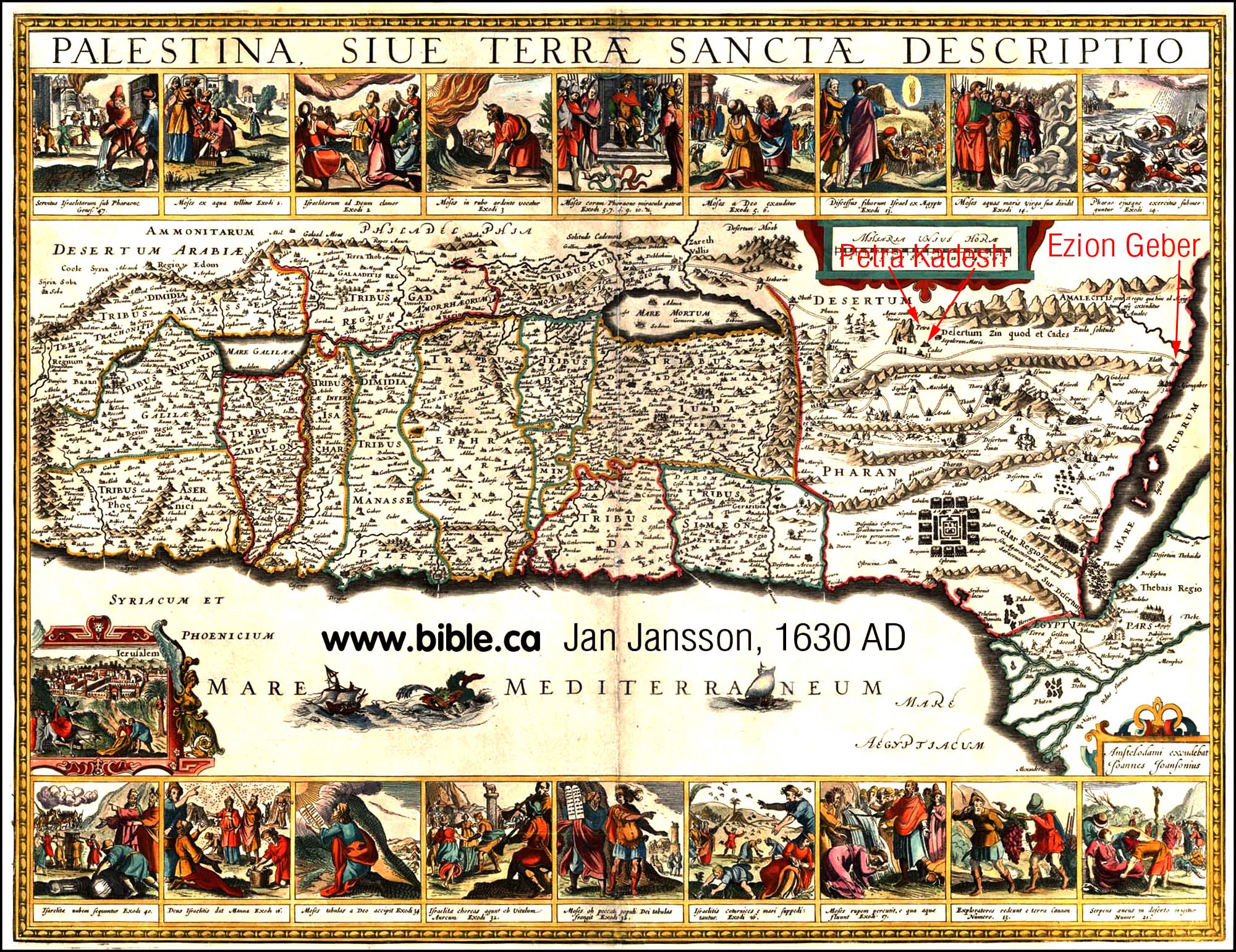
33. (1630 AD) Jan Jansson
Sinai peninsula and Gulf of Aqaba
missing. Notice he has Ezion Geber on the Red Sea. Stop 32 is Ezion Geber, stop
33 is Kadesh, stop 34 is Mt. Hor. Both Kadesh and Hor are Transjordan. Kadesh
is at Petra. What is important, is that he placed Kadesh Transjordan before
he knew the location of Petra which was rediscovered in 1812 AD by
Burckhardt.
|
 |
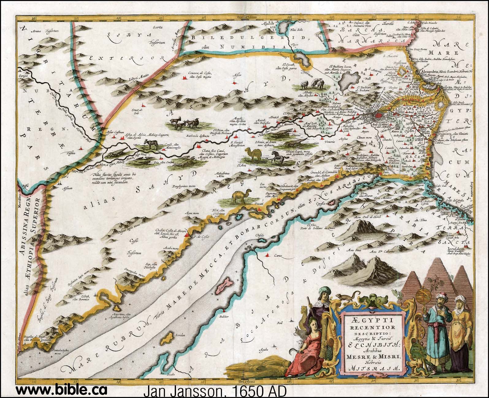
34. (1650 AD) Jan Jansson
Sinai peninsula and Gulf of Aqaba
missing.
Mt. Sinai and Jerusalem are
shown, but not Kadesh.
|
 |
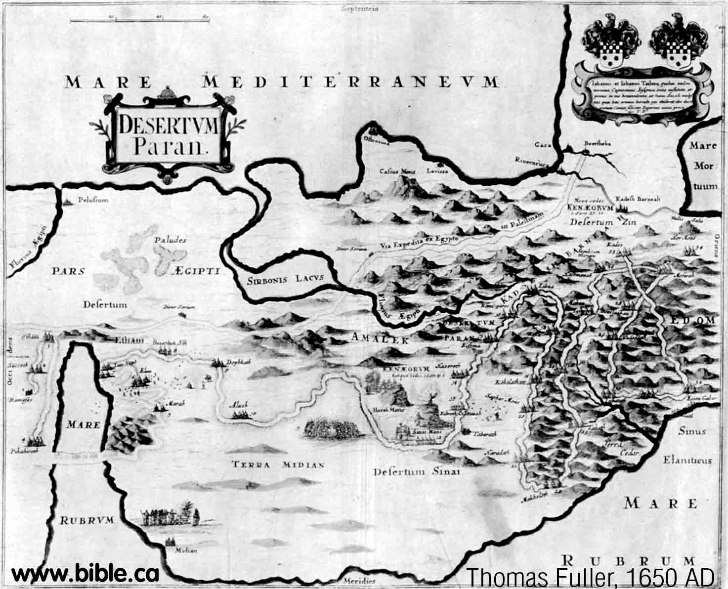
35. (1650 AD) Thomas Fuller
Mt. Seir is transjordan, due east
of the Dead sea in Moabite territory.
|
 |
36. (1650 AD) Thomas Fuller
The basic shape of the Gulf of
Aqaba is copied from Sebastian Munster's 1545 AD map. Kadesh Barnea is stop 33
and beside Petra. You can trace the standard exodus route map with numbering
system that has been around for hundreds of years.
|
 |
37. (1651 AD) John Speed
The Gulf of Aqaba is copied from
Sebastian Munster's 1545 AD map. It is the standard exodus route of the day with
a transjordan
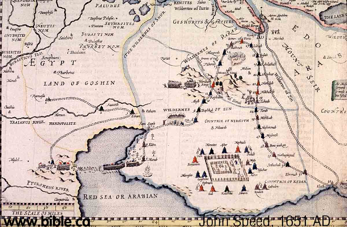 |
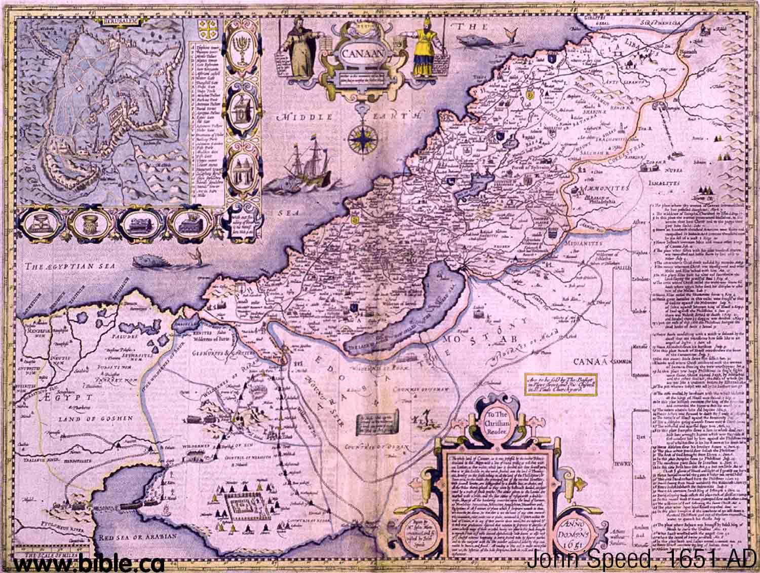
Kadesh a few stops after Ezion
Geber at Petra. Although Kadesh is beside Petra, the map is very inaccurate.
|
38. (1651 AD) Philippe de La Rue
The shape of the Gulf of Aqaba is
copied from an early map by Sebastian Munster in 1545 AD.
|
 |
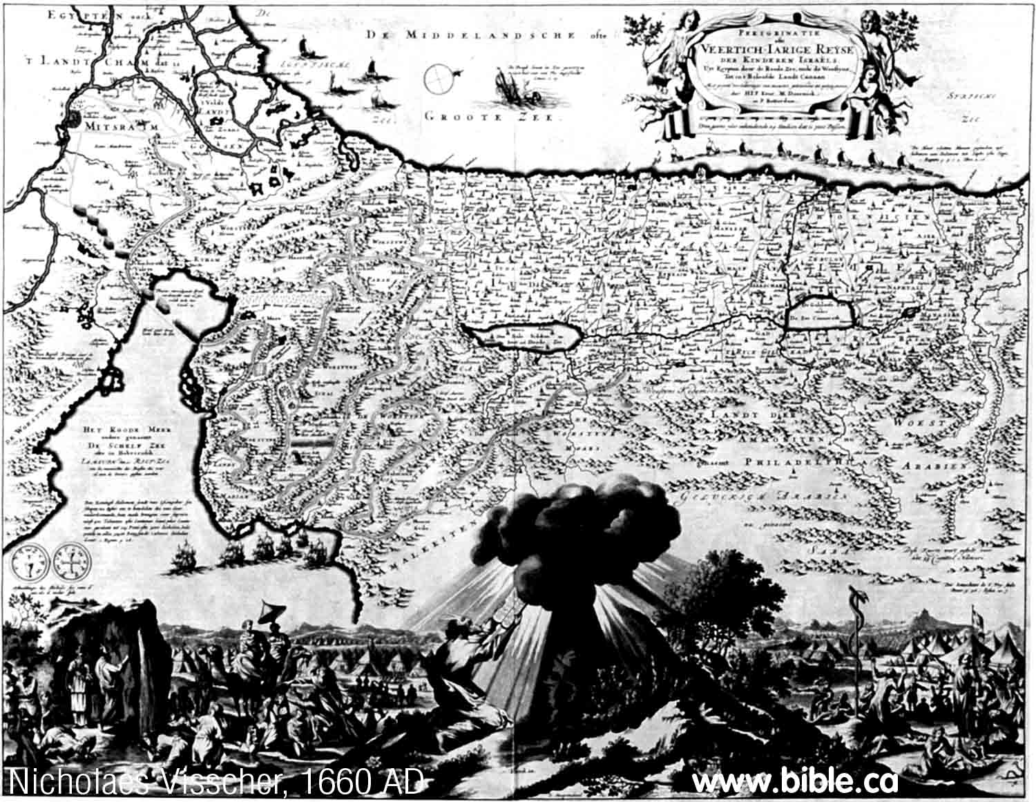
39. (1660 AD) Nicholaes Visscher
The shape of the Gulf of Aqaba is
copied from La Rue (1651 AD) who in turn copied it from Munster (1545 AD).
The crossing point of the Red Sea is at the Port of Suez and the standard
exodus route map is used where stop 33 is Kadesh which is shown transjordan
just after Ezion Geber. Ezion Geber is where the ships are sailing to in a
row. This would also be Elat.
|
 |
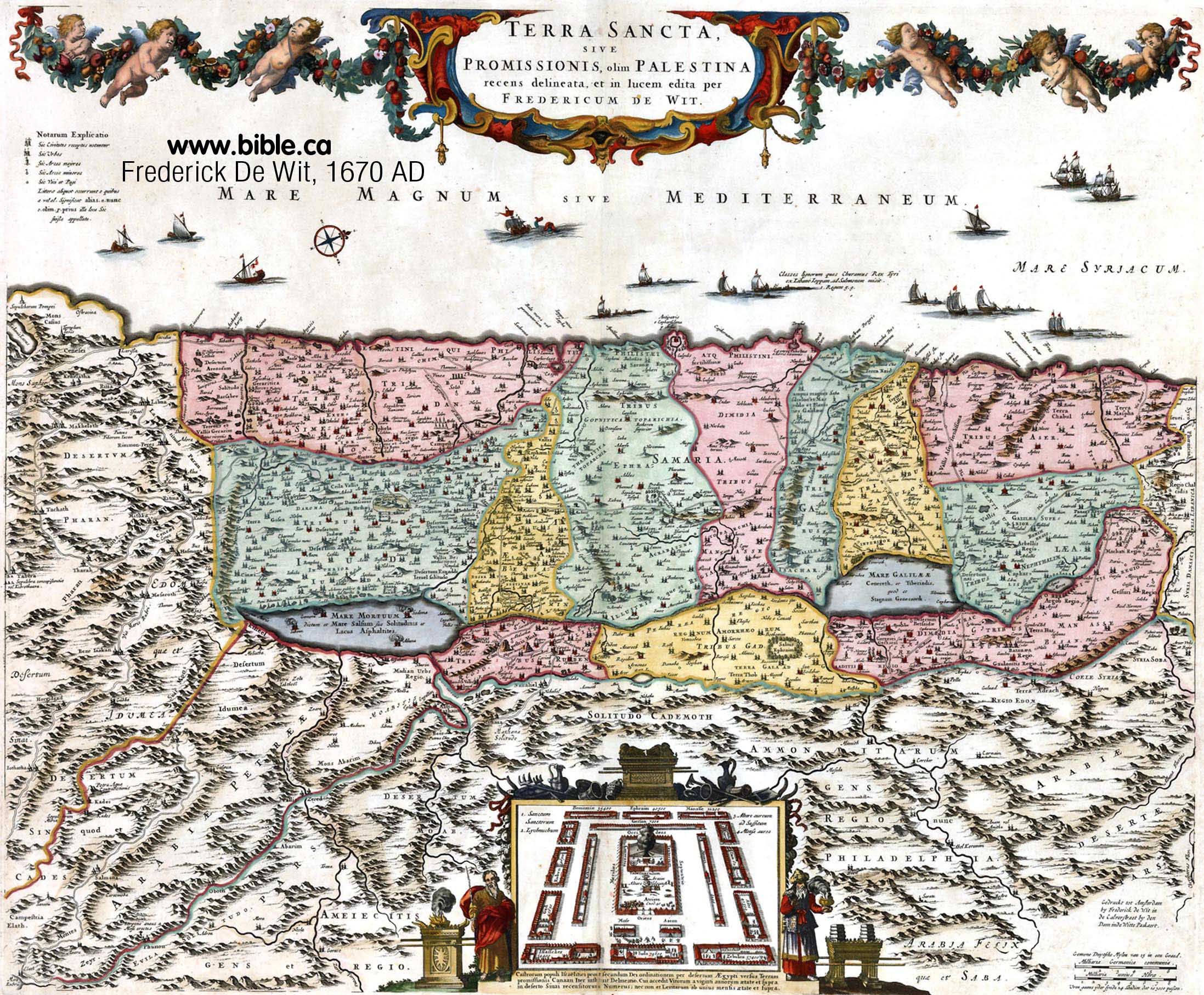
40. (1670 AD) Frederick De Wit
Sinai is at the left hand edge of
the map botton third, below the Dead Sea. Kadesh Barnea is beside Sinai at
Petra.
|
 |
41. (1671 AD) Joseph Moxon
Moxon almost exactly copies
Nicholaes Visscher's map of 1660 AD, who copied the shape of the Gulf of Aqaba
from La Rue (1651 AD) who in turn copied it from Munster (1545 AD). The
crossing point of the Red Sea is at the Port of Suez and the standard exodus
route map is used where stop 33 is Kadesh which is shown transjordan just
after Ezion Geber. Kadesh is at Petra. Ezion Geber (Elat) is where the ships
are in a row.
|
 |
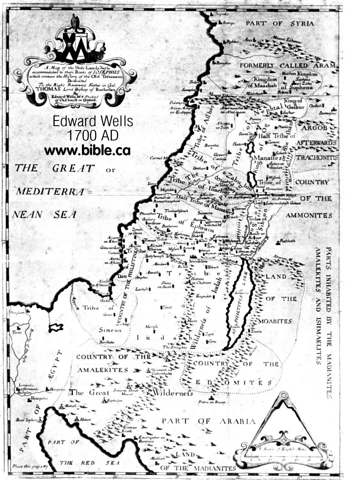
42. (1700 AD) Edward Wells
Ezion Geber is east of Elat, in
Modern Jordan, which is correct. Modern maps incorrectly put Ezion Geber on
the west side of Elat, in modern Egypt. Midian is also correctly mapped on
the east side of the Gulf of Aqaba. Petra is correctly placed on the map
relative to the Dead Sea and the Gulf of Aqaba.
|
 |
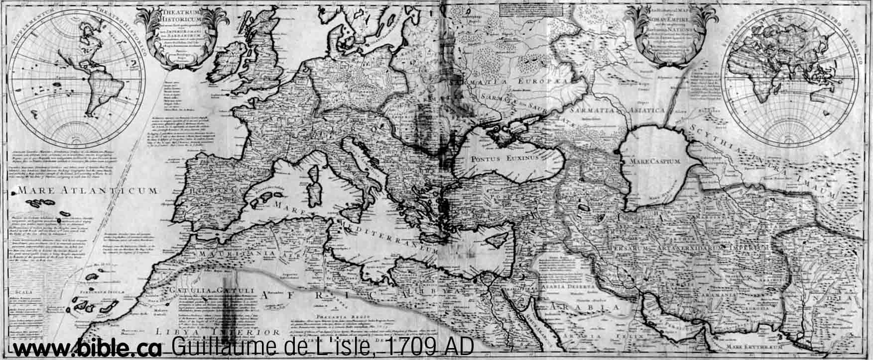
43. (1709 AD) Guillaume de L'isle
The Gulf of Aqaba is beginning to
be understood a bit better, but this is really just an exaggerated version of
Munster's 1545 AD map and does not really offer anything new.
|
 |
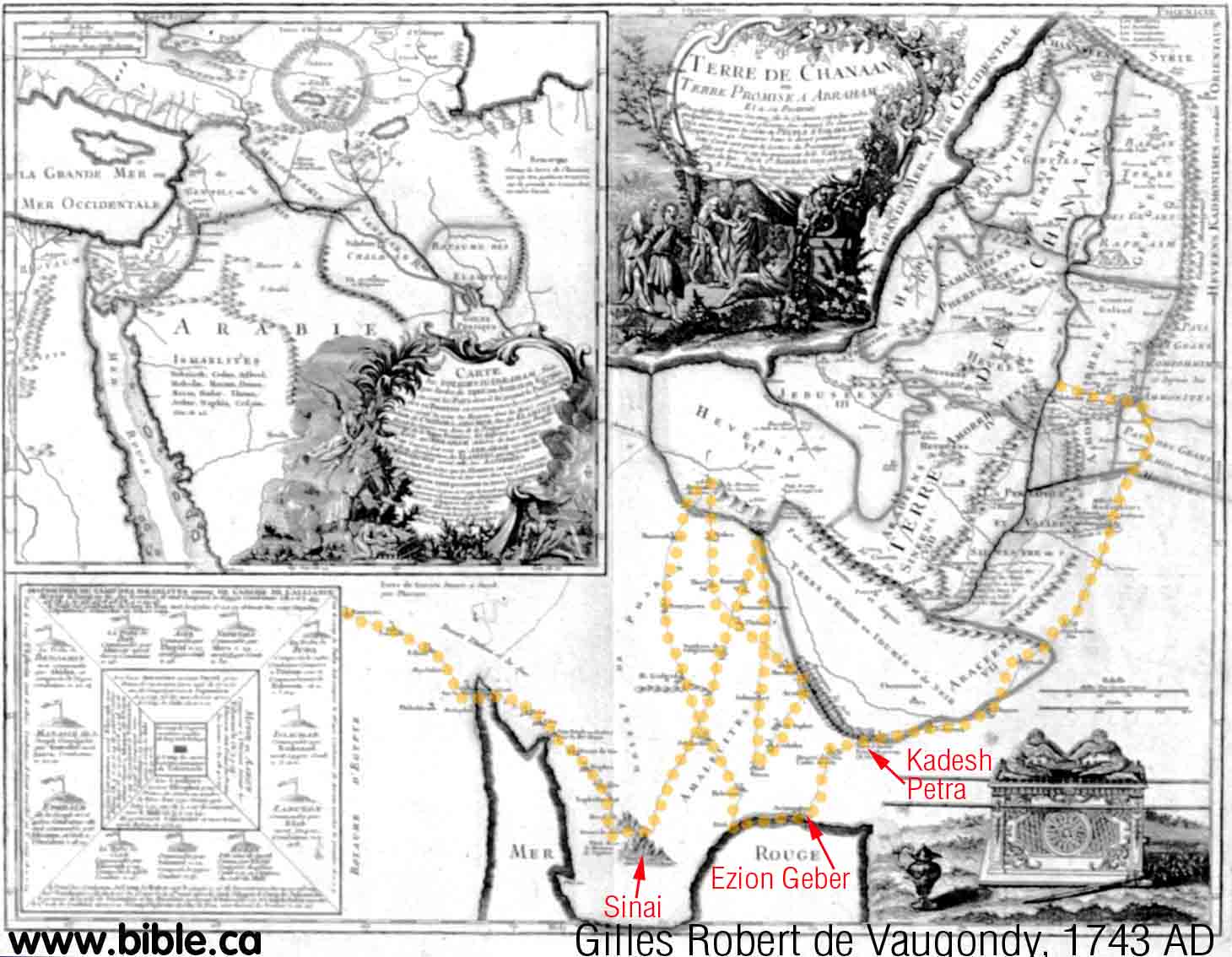
44. (1743 AD) Gilles Robert de Vaugondy
Vaugondy's Gulf of Aqaba is not
well understood and is copied from Sebastian Munster's 1545 AD map. The
exodus route is hilarious. The yellow dotted line, we put on the map, traces
over Vaugondy route from Goshen. Notice it criss crosses itself many times!
Vaugondy had quite an imagination! However he still puts Kadesh transjordan
beside Petra, one stop after Ezion Geber. Compare his route with Emanuel
Bowen's in 1747 AD.
|
 |
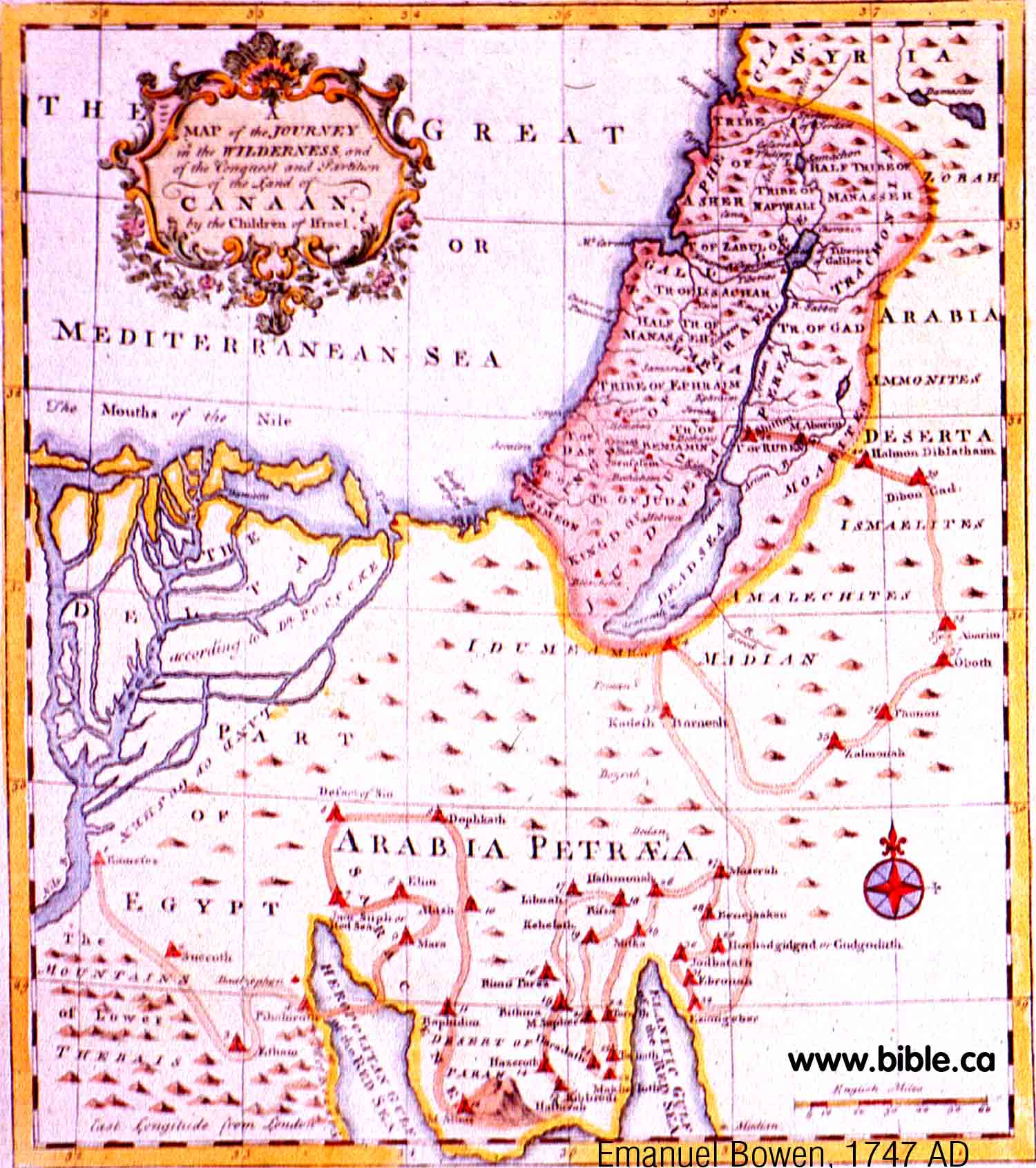
45. (1747 AD) Emanuel Bowen
Bachiene should get an award for
giving us a much improved Gulf of Aqaba! Someone must have finally sailed the
Red Sea and brought back a new map with new information! Three years later
Bachiene (1759 AD) gave a similar version of this same shape. Note that Ezion
Geber is correctly mapped on the east side of the Gulf of Aqaba, Kadesh is
transjordan at Stop 33, one stop after Ezion Geber. Strangely, Petra is not
on the map.
|
 |
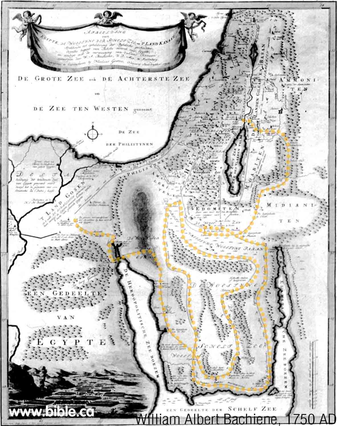
46. (1750 AD) William Albert Bachiene
Here is another map that does a
much better job of drawing the two gulfs. The Sinai Peninsula is present and
the Gulf of Aqaba is quite close to correct. Kadesh is still transjordan at Petra.
However the route follows Vaugondy's 1743 AD criss cross pattern as seen on
the yellow dots we placed on the map. Out yellow dots trace over Bachiene's
route so it can be see easier.
|
 |
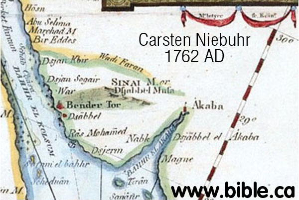
47. (1762 AD) Carsten Niebuhr
This is the very first map to
name the correct crossing point of the Red Sea at the Straights of Tiran
by marking the Island of Tiran! It shows a crude Gulf of Aqaba. Here was the
actual crossing point of the Red Sea marked on a map and Niebuhr never knew
it! However, he viewed the north tip of the Gulf of Aqaba as a "forked
tongue". This forked tongue error is seen in Kitchin's 1794 AD map in
greater detail.
|
 |
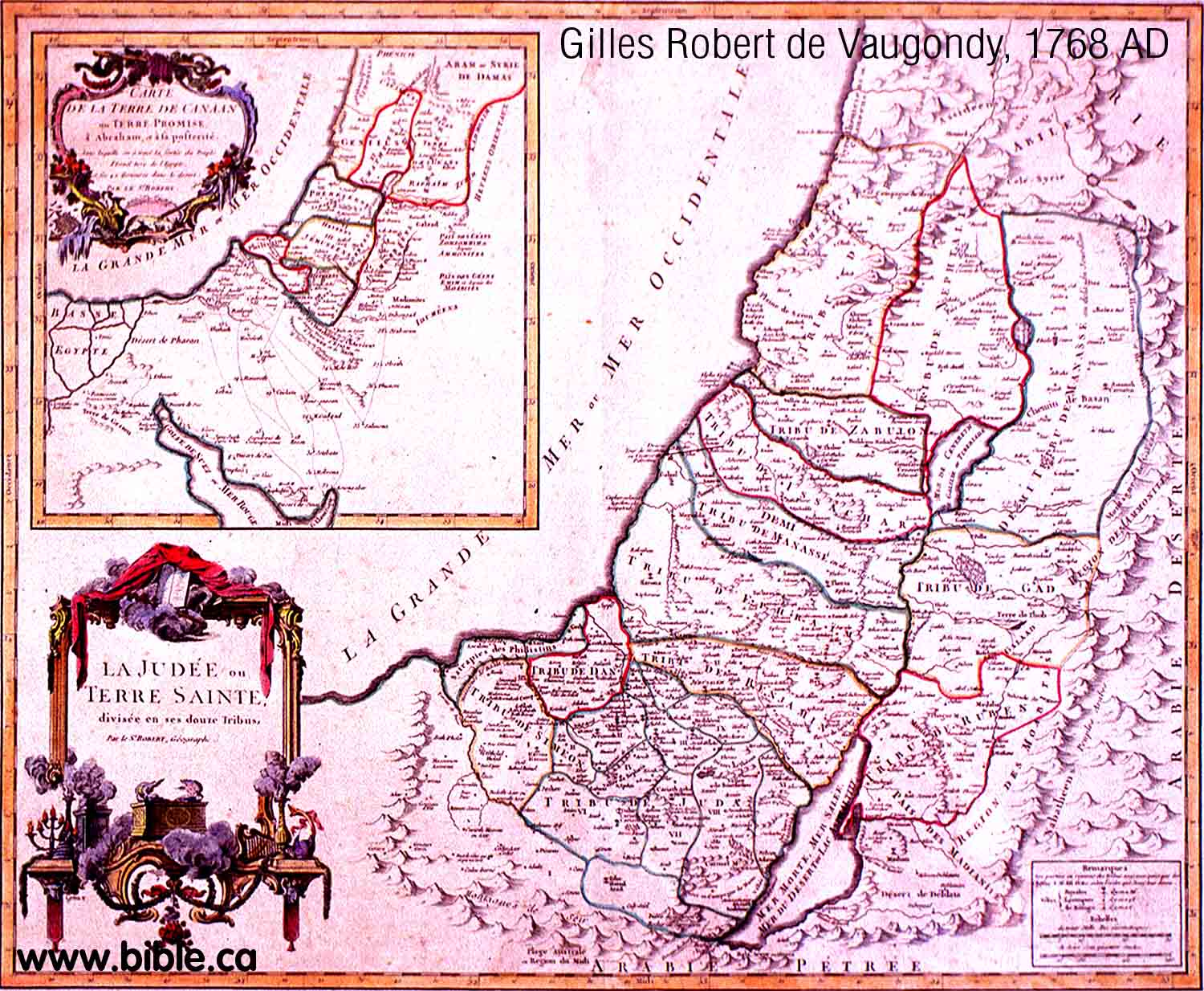
48. (1768 AD) Gilles Robert de Vaugondy
You can see in the little inset
map that the Gulf of Aqaba is still not understood. This was probably copied from
Carsten Niebuhr's map of 1762 AD.
|
 |
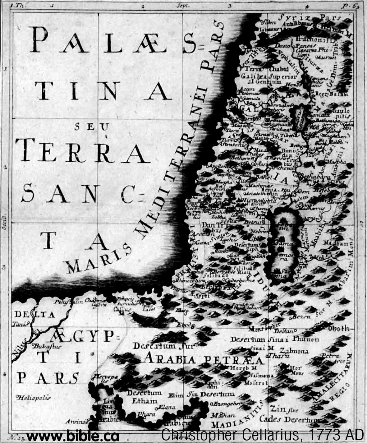
49. (1773 AD) Christopher Cellarius
This is a new variation of the
shape for the Gulf of Aqaba that was first invented by Sebastian Munsters 1545
AD. However, this unique shape is copied during into many maps in the 1700's.
Ezion Geber is seen to be on the east side of the Gulf of Aqaba. Kadesh is
transjordan at Petra and the Midianites are in Arabia.
|
 |
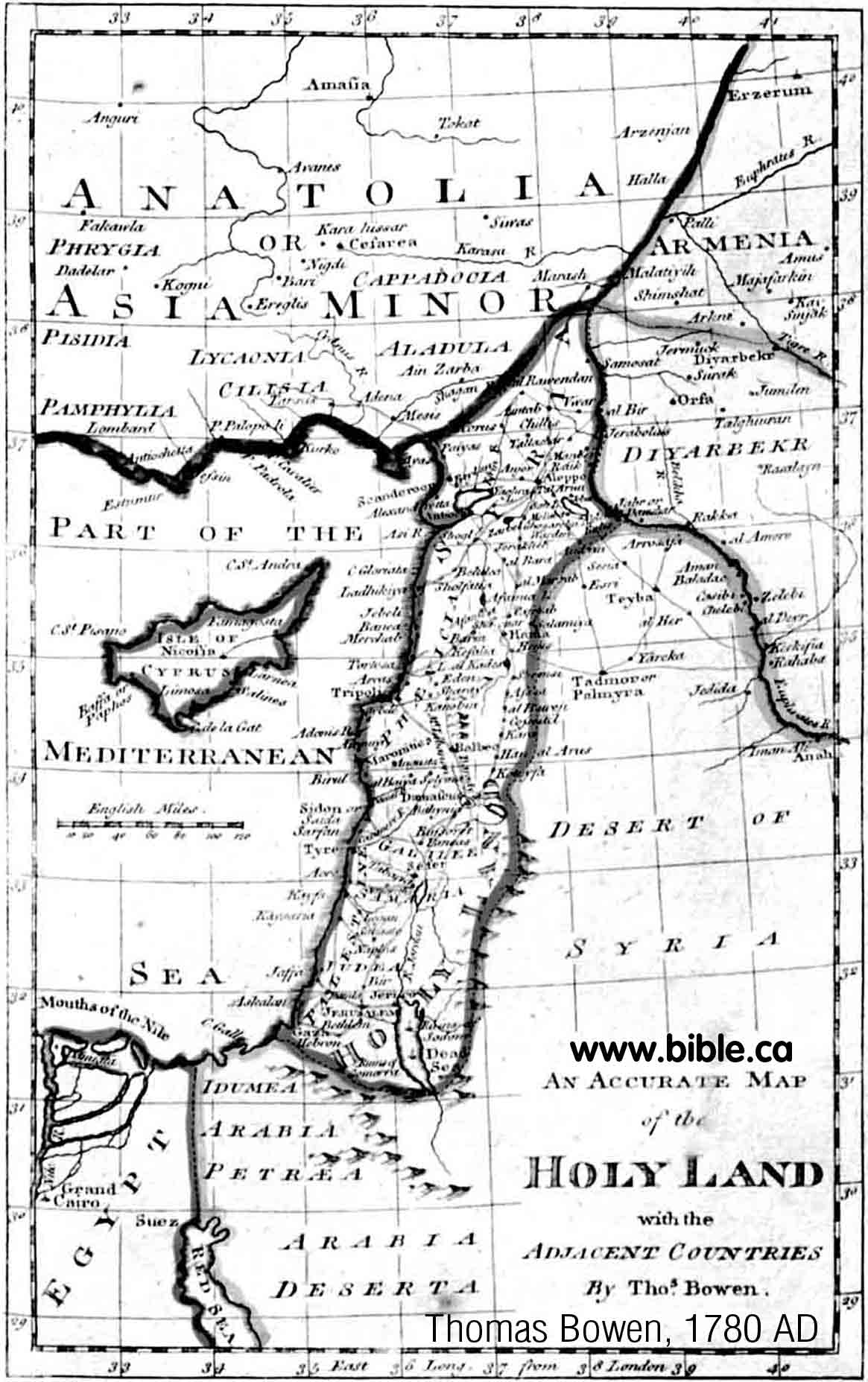
50. (1780 AD) Thomas Bowen
Bowen greatly exaggerates the
forked tongue seen in Carsten Niebuhr's 1762 AD map. The Gulf of Aqaba looks
like a hand puppet of a cute African Basenji named "Tuli the
Sentinel"!
|
 |
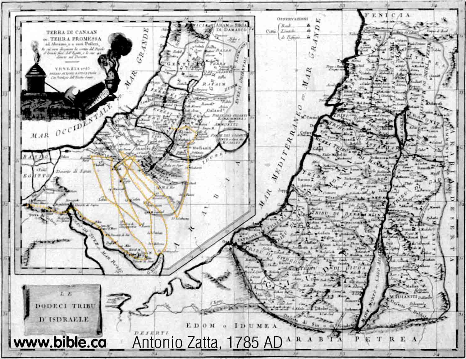
52. (1785 AD) Antonio Zatta
The shape of the Gulf of Aqaba is
similar to the 1650's. The general exodus route on this map continues the
long tradition of putting Kadesh transjordan at Petra at stop 33. This was
one stop after Ezion Geber. The route is the most bizarre example of the Zig
Zag, criss cross we have found. We put yellow dots on top of Zatta's route.
|
 |
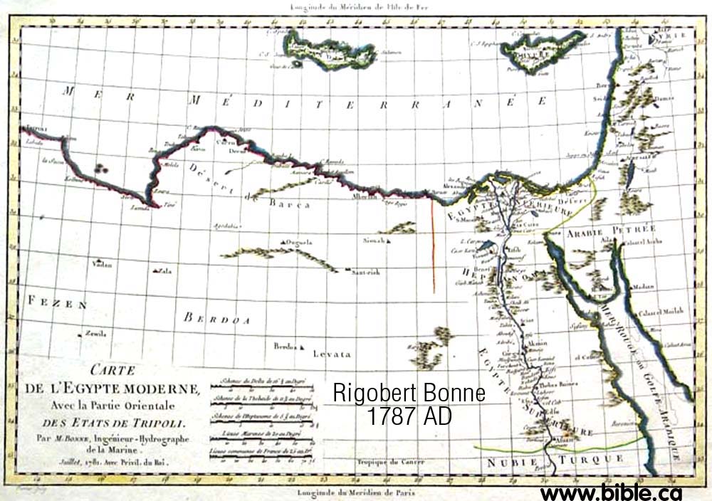
53. (1787 AD) Rigobert Bonne
Notice how the forked tip of the
Gulf of Aqaba is given greater detail. Midian is correctly placed in Arabia
at Al Bad.
|
 |
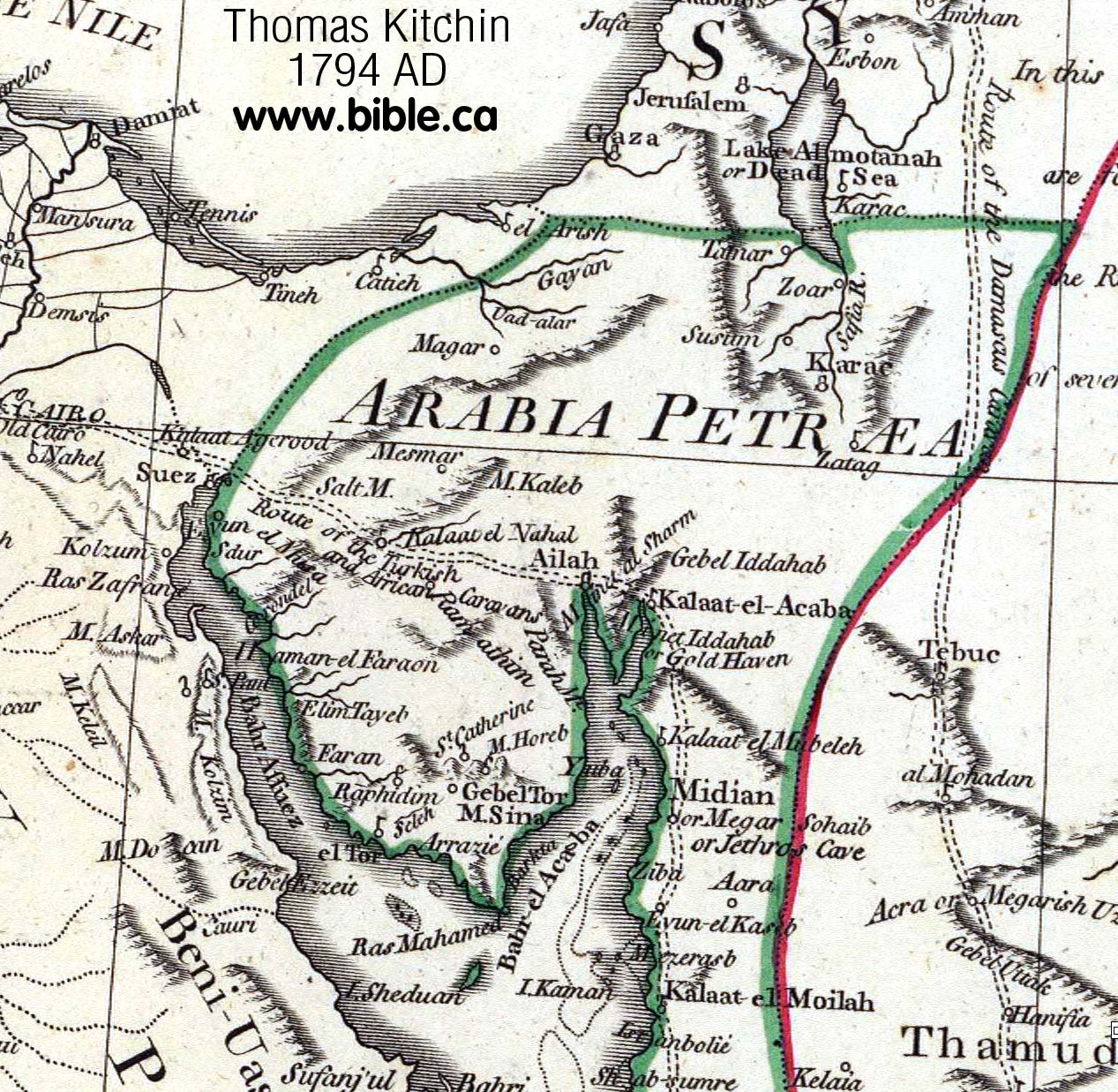
55. (1794 AD) Thomas Kitchin
The "forked tongue" of
the Gulf of Aqaba is given in great detail. All of this was imagination!
Having personally been several times to modern Elat, it is clear the northern
tip has no such feature. Although he places Mt. Sinai inside the Sinai
Peninsula, he knew that Midian (Jethro's cave) was in modern North Saudi
Arabia.
|
 |
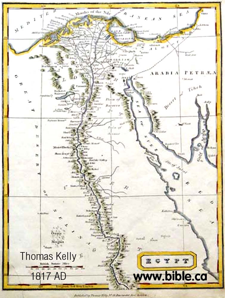
56. (1817 AD) Thomas Kelly
This is probably the last map that
showed the fork at the end of the Gulf of Aqaba before the discovery of the
Arabah valley and Petra by Johann Burckhardt in 1822 AD.
|
 |
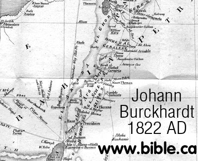
57. (1822 AD) Johann Burckhardt
Burckhardt himself observed:
"The existence of the valley El Araba appears to have been unknown both
to ancient and modern geographers, although it forms a prominent feature in
the topography of Syria and Arabia Petræa. It deserves to be thoroughly
investigated."
|
 |
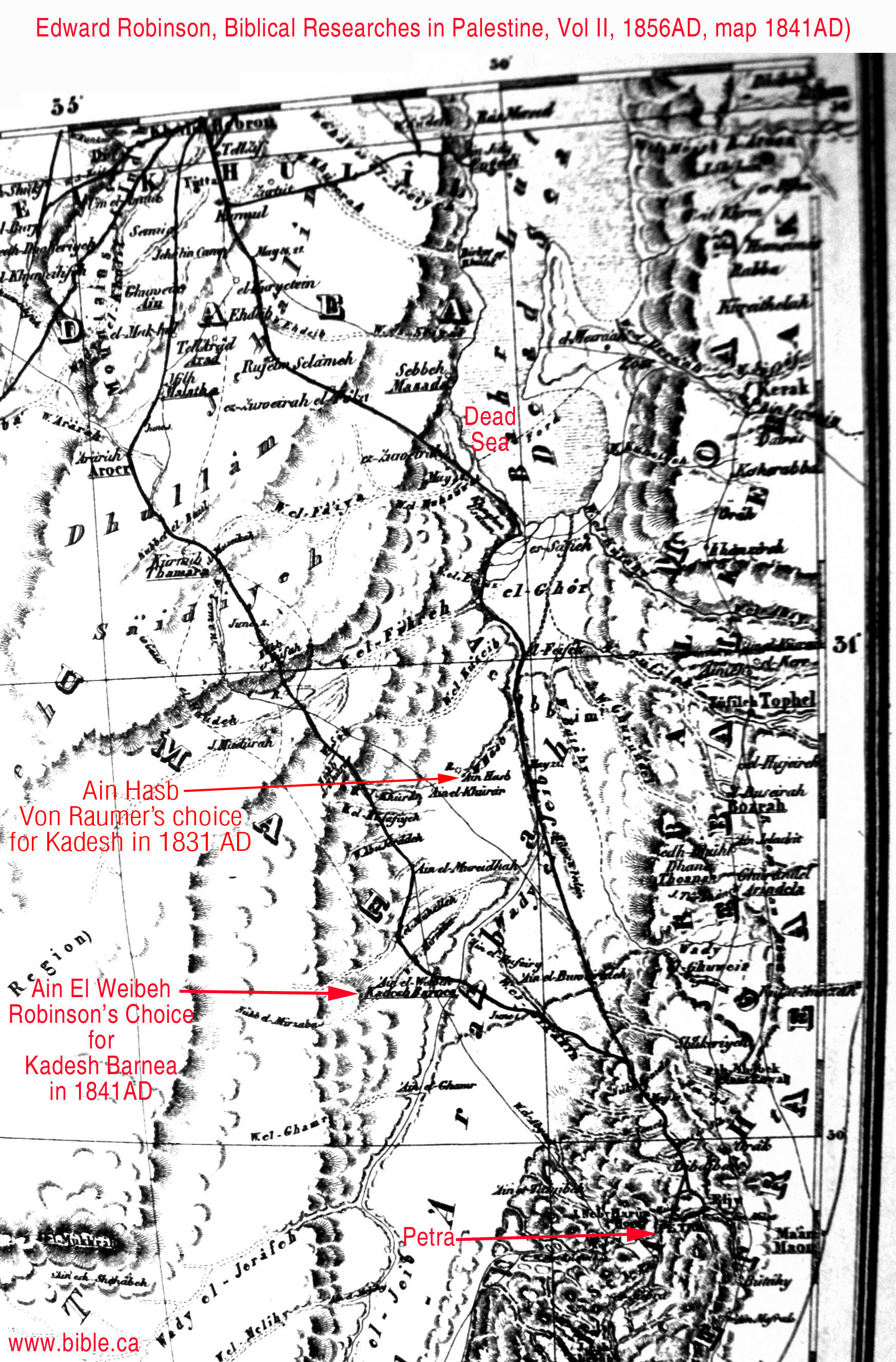
58. (1841 AD) Edward Robinson
In 1831, Karl Von Raumer's chose
Ein Hasb for Kadesh Barnea, but this was rejected by Robinson in 1841 AD who
placed Kadesh at Ain Weibeh
just a few km south. News of Petra's discovery opened up a new world of
exploration in this area. Click here
for more discussion and maps of Ein Hasb and Ain Weibeh.
|
 |
60. (1849 AD) Carl Radefeld
Radefeld made an error by not going
through Ezion Geber between Sinai and Kadesh. The gulf of Aqaba and the Sinai
Peninsula was not understood or mapped until about 1750 AD. This map is very
interesting because it shows Kadesh at Ain Weibeh.
In 1838 Edward Robinson chose Ein El Weibeh for Kadesh. Here is a map that
shows Kadesh at Weibeh in the time historical time period when this is where
the world thought it was. Notice this is not tranjordan, but just north of Petra
on the west side of the Arabah Valley. But Mt. Hor is at Petra and near
Kadesh.
|
 |
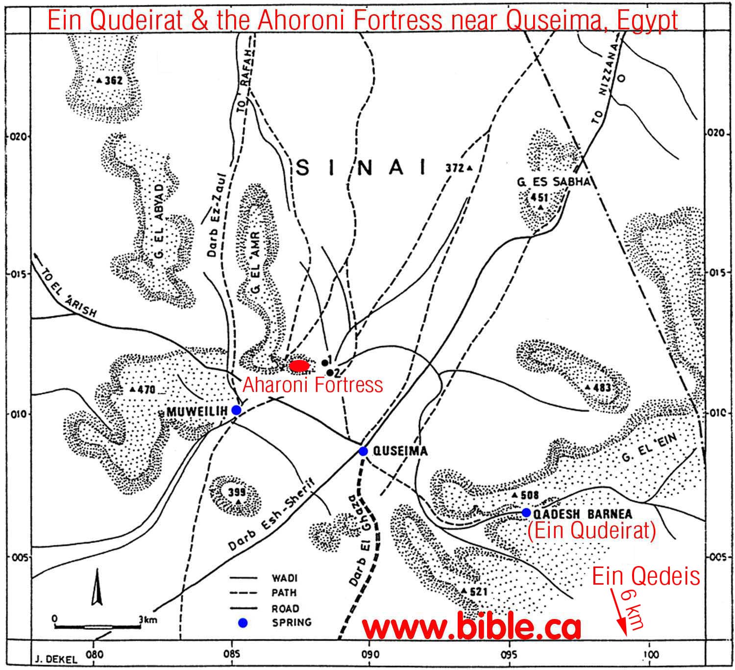
61. (1881 - 1916 AD) Ein Qedeis
In 1842 AD John Rowlands was the
very first man in history to suggest Ein
Qedeis was Kadesh Barnea. Not many took notice of this until the
deceptive account of Qedeis published by Henry Clay Trumbull in 1884 AD. In
1881 AD: Clay Trumbull visited Ein Qedeis for only
one hour, and then wrote an article in 1884 AD that formally stated
that it was Kadesh Barnea.
John Rowlands goes down in
history as the man who plunged the search for Kadesh Barnea in to the
"Dark Ages" (1881 AD - present). But Ein Qedeis would be just
another desert spring without Henry Clay Trumbull who is responsible for
literally deceiving the entire world into believing it was Kadesh Barnea. The
"one-two punch" of Rowland-Trumbull moved the worlds attention for
the location of Kadesh from the Transjordan Arabah to where it has been
presently located on all Bible maps since 1916 AD.
|
 |
62. (1916 AD)
In 1916 AD In 1914, Woolley and
Lawrence excavated Qudeirat and declared it to be Kadesh Barnea. Since they published
their work in 1916 AD down to the present time, almost every map in the back
of every Bible places Kadesh Barnea at Ein
el-Qudeirat. This is most unfortunate for a number of reasons, mainly
because it is inside the promised land.
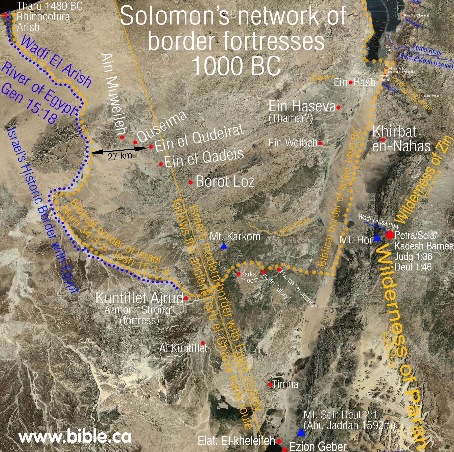
Here is a map with all the
various locations for Kadesh Barnea including ein Hasb, ein Weibeh, ein
Qedeis and ein Qudeirat.
|
 |
63. ARAB MODERN!
Lihatlah Jalur exodus musa dari mesir dan inilah jalur exodus musa yang benar, Paran dan Gunung sinai ada di kawasan Arabia dan di lintasi oleh exodus Musa inilah Peta modern yang sesuai iptek |

http://www.bible.cahttp://www.bible.ca/archeology/bible-archeology-maps.htm
(http://www.pseudepigrapha.com/jubilees/8.htm)
http://williamstev.blogspot.com/


Comments
Post a Comment